Mount Irish Radio Site
With 8741 ft., Mount Irish is the tallest peak in the Pahranagat Range, overlooking most of Tikaboo Valley and the northern Nellis Ranges. This makes it a prime location for a radio repeater facility. And sure enough, there is quite a selection of radio antennas and microwave dishes along with several small buildings and trailers on the plateau on top. The slopes of Mt. Irish are very steep, and there is no road access to the top. Just like Bald Mountain, the fully automated and unmanned facility is serviced by helicopter. Unlike Bald Mountain, however, the top of Mount Irish is on public land. So, after studying various topo maps and satellite images to find the easiest way up, Gregos and I set out to explore the site on June 6, 2008. The easiest way up is still about two Tikaboos in terms of difficulty, and even with light packs the hike up took us a good 3 hours.
The electronics for the radio site are housed in four small buildings and storage containers. The cables from the antenna tower all lead into the largest of the buildings. The site is powered by two large solar panels. There are also a number of propane bottles next to one of the buildings. Possibly for a backup generator or for heating the buildings in winter. There is a level area just east of the buildings where a helicopter can land.
The view from the top of Mount Irish is spectacular. However, it does not have a view of Area 51. The only visible part of the Groom Lake Base is the explosives storage area and the engine test cells at the far south end of the base and the south end of the runway. The Groom Mountain Range obstructs the view of the main facility.
At one point Mt. Irish was a central hub for the original ACMI Range system used for the Red Flag exercises, which provides controllers at Nellis with exact 3-D position data on all airborne players. The old ACMI sites on Flat Top and on Badger Mountain were pointed to Mount Irish.
The original ACMI system has since been replaced with the newer Nellis Air Combat Training System (NACTS), with a central hub located on Highland Peak, near Pioche. Around 2013 that system was in turn replaced by the P5CTS system. As of this update in June 2023 Mount Irish serves as a hub for the Badger Mountain site and as a relay between Ella Mountain and Cedar Peak via Ragged Ridge, two central hubs for the new system.
The large dish is a microwave relay to Ragged Ridge and ultimately to Cedar Peak, a central hub for the Nellis Digital Microwave Communication System (NDMCS) used in the NTTR. The microwave relay operates in the 7GHz range. The relay also serves the P5CTS system above. It also appears that there may be a linkup for IP-based mobile data terminals on the ground or in the air. We found a couple of antennas that may provide WiFi access.
Other radio installations on Mount Irish include a repeater for the Lincoln County Sheriff (input: 154.070 and 155.535 MHz, output: 154.860 and 155.205 MHz) and a site of the NV Shared Trunking system. The output frequencies are 856.4625, 857.4625, 858.4625 and 859.4625 MHz, in that LCN order. There is also a smaller directional antenna that looks like 900 MHz, pointed north. We were not able to determine what that antenna is used for.
The relay for the Rachel phone system is a passive reflector on Sanderson Mountain, about 0.6 miles NE of Mount Irish. It bounces the signal from the Rachel transmitter on the north side of Tempiute Mountain to the phone company building in Alamo. It is listed in the FCC database as a passive repeater. That microwave link does not have a connection to Bald Mountain or to Area 51.
There is also another, much smaller repeater site on Sanderson Mountain, about 0.8 miles north-east of Mount Irish. We currently have no information on that site.
The GPS coordinates of the top of Mount Irish are N37°38'41.0" / W115°24'5.4". There are at least four survey markers at the top. Three markers from the U.S. Coast & Geodetic Survey date back to 1944. The fourth marker of the Defense Mapping Agency is from 1985 (see photo below). This marker is similar to a marker found on Badger Mountain. It seems likely that 1985 is the year the original ACMI system was installed.
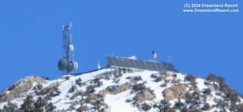
This updated 02/2024 photo shows that the gray dish has been adjusted to point to Ragged Ridge instead of previously to Cedar Peak. The large dish in the back connects to Ella Mountain. The white dish about halfway up connects to the Badger Mountain ACTS site. The two smaller dishes near the top of the tower are gone. They were a proprietary data link for the old NACTS system. The new system is designed to use broadband microwave data. Photo taken 02/27/2024. |
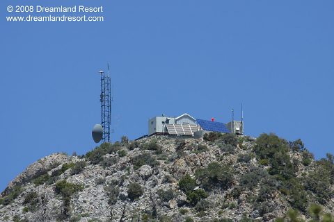
The radio site on top of Mount Irish. Three of the four buildings/containers are visible. The building on the left, closest to the antenna tower, houses most of the radio equipment. Two large solar panels supply power for the site. |
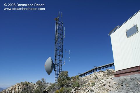
The antenna tower of the Mount Irish site. All antenna cables lead into the building on the right. The large microwave dish points to the Ragged Ridge radio site, which is part of the NTTR microwave backbone. Photo by Gregos, with friendly permission. |
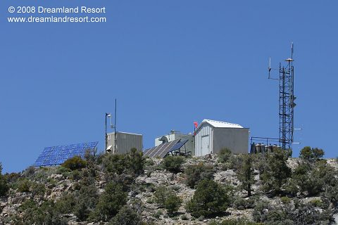
This photo shows the entire site. A small, remote-controlled camera, similar to models used in banks or casinos, is mounted to the container on the left. However, it did not move while we were up there, but was pointed down a steep slope, away from the radio site. It did not appear to be in use. Also mounted to the container is a white omni-directional antenna that looks like it could be for WiFi access. The white tube is approximately 90cm (36") long and the metal tip measures about 23cm (9"). Its twin is mounted near the top of the antenna tower. The antennas on the tower are discussed in the next two photos. |
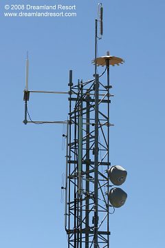
The brush at the very top of the antenna tower is a lightning protector. Below it is the omni-directional aircraft uplink for the NACTS system. The white antenna next to it is a twin of the one mounted to the container in the previous photo. It looks like it may be for WiFi access. Below it is a folded dipole array with two 1/4 wavelength loops for the 150MHz Sheriffs repeater. The blue dipole is for the 800MHz Nevada Shared Trunking System. The two dishes are a 1.8GHz microwave link to the hub of the NACTS system on Highland Peak. |
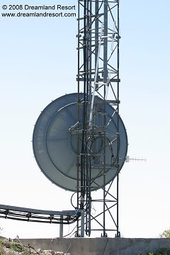
The large microwave dish is a 7.3GHz link to the NTTR system on Ragged Ridge. The two loops are another folded dipole array for the 150MHz Sheriffs repeater. The small directional Yagi antenna on the right points roughly north. It looks like 800/900MHz, but we were not able to determine an exact frequency or purpose. |
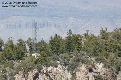
This antenna tower is located on a slightly lower plateau north of the top of Mount Irish, about 0.8 miles north-east of the peak. We have no information on the use of this radio site. |
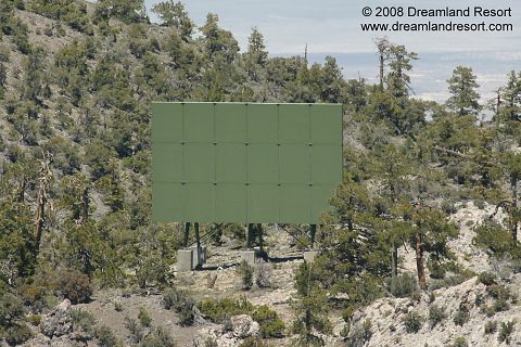
This reflector north of the peak of Mount Irish bounces the microwave signal for the Rachel telephone system from the transmitter on a mountain near Rachel to the receiver in Alamo and vice versa. It is listed in the FCC databasse as a passive repeater. There are no phone lines to Rachel. All phone, cell phone and internet traffic uses this passive repeater. |
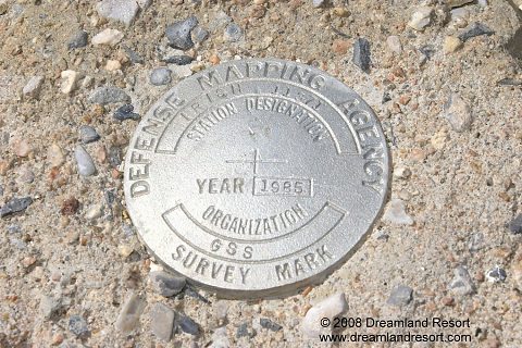
There are at least four survey markers at the top of Mount Irish. Three markers from the U.S. Coast & Geodetic Survey date back to 1944, probably the year when the first radio site was installed here. This marker of the Defense Mapping Agency is from 1985. It is very similar to a marker on Badger Mountain, near the ACMI/NACTS site there. It seems likely that 1985 is the year the original ACMI system was installed. |
© Copyright 1999-, Dreamland Resort. All rights reserved. Copyright Policy Privacy Policy Page last modified 02/27/2024


