Flat Top Radio Site
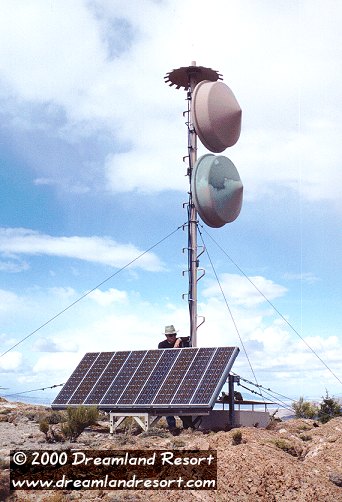 There is a network of small unmanned radio facilities on the mountaintops around the Nellis Ranges and Area 51. They are part of the Nellis Air Combat Training System (ACTS), which is used to provide real-time 3D position data for aircraft during the Red Flag exercises, and quite possibly also for test flights out of Area 51.
The sites are usually unmanned, and only occasionally serviced by a helicopter crew. The electronics module is powered by a solar panel, which is buffered by a good size battery pack. In the photo on the left the electronics module is at the foot of the antenna pole, covered by the solar panel array. The battery pack can be seen behind it, in the square metal case that is covered with a metal shield to keep it from overheating in the sun.
This site was on Flat Top, north of Queen City Summit. It was part of an older version of the Nellis ACTS system, known as Red Flag Measurement and Debriefing System (RFMDS). The dishes were pointed southeast, towards Mount Irish. In September 2001 we discovered that this site was completely gone, after RFMDS was replaced by the NACTS system with a greater range.
A very similar site is located on Badger Mountain. It, too, is no longer used, but has been replaced by a newer system right next to it.
© Copyright 1999-, Dreamland Resort. All rights reserved. Copyright Policy Privacy Policy Page last modified 02/10/2024