
A radio facility can be seen on top of Badger Mountain, northeast of Tikaboo Peak. It was expanded in 1998, and it is part of a radio system that provides real-time 3D position data for aircraft during Red Flag air exercises. A total of 15 such sites in various locations form the Nellis Air Combat Training System (ACTS) Range within the Nellis Range complex. There is some good evidence that the system is operated by Cubic Defense Systems, a civilian contractor and according to their web site "the worldwide leader in combat training systems".
Some say there is also a camera on top of Badger Mountain, to watch the trail up to the Area 51 view spot at the top of Tikaboo. Photos of the site from Tikaboo showed some detail (see bottom photo), but not enough to satisfy my curiosity.
There is no road access to the site, but it is located on public land. A hike up to it seemed doable, so after studying various terrain photos and topo maps I set out to end the speculations in the early morning of June 29, 2002, after camping the night at the Tikaboo staging area (see our Tikaboo Peak Map). The hike turned out to be more than the expected 1.5 Tikaboos, but after a little over two hours I was at the site. To the best of my knowledge this was the first time anyone has hiked up to it.
First off, there is no camera up there, and I did not find any evidence that there had ever been one.
There are two pairs of dish antennas on top, pointed in different directions. Each pair is mounted on a separate pole and has its own electronics module and battery unit. The two dishes of each pair are identical, and pointed in the exact same direction. There is no cable connection between the two systems, and they appear to be completely independent. They seem to be part of two independent systems in different directions from Badger. Both systems also have a short omni-directional "stub" antenna on top of the pole, with a metal ground plane that looks like an umbrella in the photos below.
The larger pair of dishes points dead on to Mount Irish, at a magnetic heading of 335° (348° true). The smaller pair points to a magnetic heading of 40° (53° true). This is roughly in the direction of Pioche.
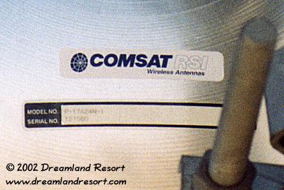
On closer examination of the transmitter pointed to Mount Irish I made a somewhat surprising discovery: The electronics module has been removed from the casing (see photo below), the cables have been disconnected, and the solar panel is missing. Quite obviously the site is no longer in use. This confirms my earlier observations that a similar site on Flat Top had been removed as well.
The site pointed towards Pioche appears to be in operation, although I was unable to lock on to a frequency with my 2.4GHz counter. Now of course it would be interesting to know where the counterpart, the central hub, is. A microwave dish requires line of sight. That puts it on a mountain top. Looking at the topo map, the most promising candidate by far is the 9395 ft. Highland Peak about 5 miles southwest of Pioche, and about 55 miles from Badger Mountain. According to the topo maps there is a road leading up to its top, and some sort of radio facility can be seen on top in detailed satellite images. In 2007, we confirmed the location of the hub on Highland Peak by the direction of the dishes of a similar site on Mount Irish.
It appears that Mount Irish is no longer used as a central hub for the NACTS Range system, and that it was replaced around 1998 by a newer system with a central hub on Highland Peak. Around 2015 the eastern hub seems to have moved again to Ella Mountain. Around in the late 2010's, when the site was upgraded to the new NACTS 2.0 standard, the dish once again pointed to Mount Irish. So it appears they came full circle and as of this update in June 2023 Mount Irish is once again the hub for this site.
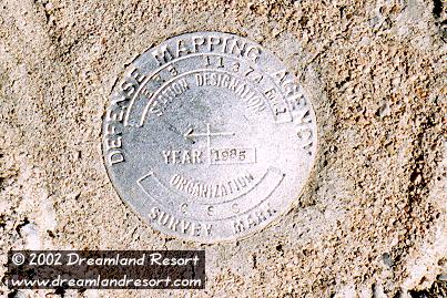
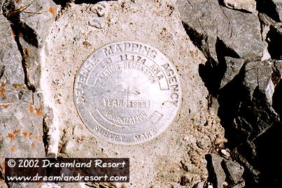
Besides the two transceivers sites I found two survey markers of the "Defense Mapping Agency" (see photos below) and a clearing where the helicopter drops off the maintenance crew, some 50 or 100 feet southeast of the two repeaters.
The GPS coordinates of the Badger Mountain site are: N 37° 21.295' / W 115° 19.531'. The distance to Tikaboo Peak is 2 miles, bearing 234°. The distance to the Groom Lake Base is 28.1 miles, bearing 239°. The view at the base is blocked by Tikaboo. A partial view may be possible from a location further north, but it is most likely not nearly as good as from Tikaboo.

|

|

|
|

|

|

|
|
|
|


