|

This 2024 photo shows no significant changes to the Ragged Ridge site since the 2021 photo below. Click in the photo to zoom in. Photo taken 02/21/2024.

This 2021 super hi-res photo of the Ragged Ridge site shows various omni-directional antennas mounted to the new tower on the right. The smaller microwave dish to Mount Irish has been replaced with a much larger dish mounted to the base of the new tower. A new mobile threat simulator is parked on the platform in front of the new tower. Click in the photo to zoom in. Photo taken 07/23/2021 by a photographer who wishes to remain anonymous.

This photo shows the new antenna tower at the Ragged Ridge radio site. It also shows that the dish on the right side of the building, which was pointed to Cedar Peak, is gone. Click in the photo to zoom in. Photo taken 03/14/2020.

This photo of the Ragged Ridge site was taken on 02/07/2019. Not much has changed since the 2001 photo below except for some antenna upgrades. A new microwave dish on the tower provides a link to Mount Irish. Click in the photo to zoom in.

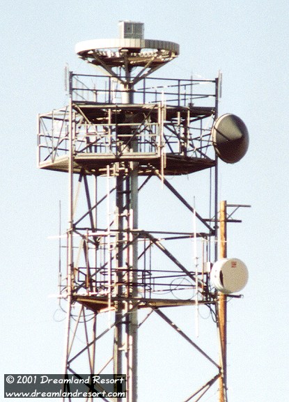
The Ragged Ridge radio site in 09/2001. Click in the photo to zoom in.
 The radar to the left and below is very similar to the one above, but located north of Tonopah. The site there is on public land, but marked: "US Government Property. No Trespassing". The dish there is pointed southeast, again towards TTR. The radar to the left and below is very similar to the one above, but located north of Tonopah. The site there is on public land, but marked: "US Government Property. No Trespassing". The dish there is pointed southeast, again towards TTR.
The close-up below shows what looks like a ring of individual sensors or small antennas, each one individually connected to the box in the center, from where thicker cables lead down to an electronics shack at the foot of the antenna. It would appear that the box in the center is some sort of multiplexer that condenses the signal from the individual antennas. We have seen several of these antennas on peaks around TTR.
This is of course an interesting design: Imagine a ring of antennas, each one directional, facing away from the center of the circle. If you poll them with the electronics box in the center doing a time multiplex, you essentially have a very fast rotating 360 degree radar without any moving parts, and with a high resolution and fault tolerance due to overlap of the segments.
This design appears to be a Doppler Direction Finder. A Doppler Direction Finder works by quickly switching between receiving elements, thus virtually rotating an antenna. By doing this, and measuring the shift in the received frequency, it is possible to calculate the direction of an incoming signal. By linking several of these systems in different locations it is possible to calculate a position fix for a transmission. Most likely the units are tuned to UHF transmissions of military aircraft. They may be used to test the susceptibility of (test-)aircraft to passive radiolocation techniques.
Any further input on these systems is greatly appreciated. All photos taken in September 2001.

| 


