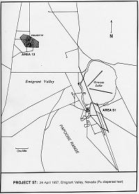
This map shows the location of the Project 57 site in Area 13 and its relation to Area 51. The groom lake airbase is shown much as it appears today.
Such experiments were necessary because aircraft crashes and other operational and logistical accidents involving nuclear weapons could result in one-point detonation of the weapon's high explosive components, producing no nuclear yield but contaminating the local area with radioactive materials. Project 57 was designed to study the particle physics of plutonium, biomedicine of animals exposed to the fallout, radiation monitoring, and decontamination of plutonium-contaminated surfaces. According to Chuck Hansen, in U.S. Nuclear Weapons: The Secret History, the weapon used was an XW-25 warhead, with a design yield of 1.5 kilotons. The XW-25 was 26.7-inches long, 17.4-inches wide, and weighed about 218 pounds. It was designed to be the warhead for the Douglas MB-1 Genie air-to-air-missile. A formerly secret document detailing the minutes of the first meeting on Project 57 states that the weapon was to be "fired on the ground at the bottom detonator."
 This map shows the location of the Project 57 site in Area 13 and its relation to Area 51. The groom lake airbase is shown much as it appears today. |
The Project 57 test site was added to the NTS as Area 13, an approximately 10-by-16-mile block of land abutting the northeast boundary of the Test Site, and partially overlapping the Watertown facility. The overlap area was not considered part of Area 13. Ground Zero for the shot was only five miles northwest of Groom Lake and seven miles from the main cantonment area of the airbase. Personnel approaching the site from the NTS would drive over Groom Pass from Yucca Flat, then head north on Valley Road for about eight miles to reach the turnoff for Ground Zero.
A formerly secret AEC report dated 14 March 1957 described the new test area, stating that it "is not contaminated to a degree that would effect the experiment, and, when contaminated, will not interfere with the conduct of the PLUMBBOB nuclear tests which are scheduled to begin in May 1957. The Armed Forces Special Weapons Project has obtained approval for the use of the land for the test." An appendix to the report contained a letter to Brigadier General Alfred D. Starbird from Maj. Gen. Alvin R. Luedecke, USAF, Chief of the AFSWP, further explained that "entry into the area has also been approved and has been coordinated with the agency which has been using the Range." The XW-25 warhead was flown to the airstrip at Yucca Flat, then trucked to Watertown. It was stored in Building 10 prior to being moved to Area 13 for final placement.
The Project 57 shot was originally scheduled for early April, but was pushed back several times. Personnel at Watertown were undoubtedly evacuated before the shot in case of unfavorable winds that could spread plutonium over the airbase, or an unexpected nuclear yield. Evacuation must have been terribly inconvenient to flight test and training operations at Watertown. According to declassified documents, most of the delays were due to unfavorable weather conditions.
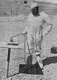
Finally, on the morning of 24 April, the signal was sent to the detonator, and the warhead's high explosive charge destroyed the weapon. Although there had been no obvious atomic explosion, a three-man team in protective clothing was dispatched to determine whether or not any beta or gamma radiation hazard existed from a partial nuclear yield. There was none, but all personnel entering the area were required to wear full protective suits and respirators to shield themselves from alpha radiation emitted by plutonium.
Plutonium emits alpha particles, the weakest form of radiation. A sheet of paper is sufficient shielding against alpha radiation. Although alpha particles are highly energetic, they are not capable of penetrating the dead layers of skin on the surface of the human body. If inhaled, however, even microscopic quantities will cause damage to soft tissues. Particles of plutonium that are absorbed into the bloodstream may be deposited in the lungs, liver, lymph nodes, or in the surfaces of newly formed bone. There, they can cause damage leading to cancer, chronic anemia, osteoporosis, or bone necrosis that may produce spontaneous bone fractures. Such results may not manifest until 10, 20, or even 30 years after deposition, depending on the size of the dose. Lung damage may become apparent in only a few years.
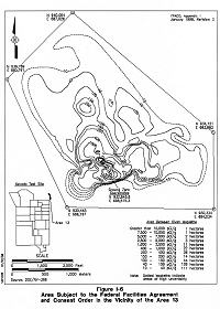
Project 57 contaminated over 895 acres with plutonium and americium dust and fragments. The primary hazard to personnel is from resuspension of small particles of plutonium dust in the air. Soil samples taken in the late 1990s indicate that plutonium particles at Area 13 are mostly smaller than 40 microns across. The exact amount of plutonium expended for the test remains classified, but one pound of plutonium involved in a fire or explosion could produce, under moderate wind conditions, hazardous contamination as far as a mile downwind.
Initial readings at radiation monitoring sites indicated no detectable fallout at Watertown. According to a declassified telex dated from the day after the shot, air samplers were "operating in all populated areas," and would be checked "after a five day seasoning period and it [was] expected that readings [would] be minor." After all samples were studied, it was determined that there was minor alpha activity for 12 days following the shot, but it was "well below operational guidelines." Nevertheless, this meant that resuspended plutonium dust was reaching the airbase in small amounts.
As described in an AEC report on Off-Site Radiological Safety Activities For Project 57, there were two high-volume air samplers located at Watertown and fallout trays located on the roofs of the Air Weather Building, and a building behind the Maintenance Shop. Minor alpha counts were detected in the trays. Samples of rainwater were collected eleven hours after shot time when a brief shower passed across Area 13 and then across Watertown. The samples contained both alpha and beta particles. Water from the Deer Camp Watering Hole east of Area 13 was also sampled, but only contained a small amount of alpha radiation.
 A Project 57 technician in anti-contamination gear picks up a sample tray with a magnetic device. |
For the particulate physics study, surface and airborne plutonium levels were measured as a function of time after detonation. Air samplers, balloon-borne precipitators, soil samples, and photographic methods were used. Scientists constructed a fallout pattern model using a grid of more than 4,000 sticky pans distributed over a 43-square-mile area. They also analyzed the fractionation characteristics and physical nature (size, shape, and distribution) of the fallout particles. Interestingly, the maximum air concentration levels of alpha contaminants were found at a distance of 5,000 feet from the detonation point.
A biomedical field study examined environmental short-term and chronic effects of plutonium inhalation and persistency of debris resulting from subcritical bursts. For this experiment, a group of test animals (dogs) were exposed to the radioactive cloud to test the effects of acute exposure. A larger group of dogs was placed in the contaminated zone for a longer period of time to study the effects of chronic exposure. Test animals were periodically sacrificed and autopsied by veterinary scientists to collect data.
A third study was undertaken to practice monitoring of alpha contamination on various surfaces. This effort correlated alpha monitoring data from sticky pan collectors with field study data from broom-finished concrete slabs. The slabs and sticky pans were placed adjacent to each other at various locations throughout Area 13. The monitors also took readings from nearby soil and vegetation.
The largest effort was expended on developing techniques for decontamination of large surface areas. Technicians studied plutonium removal from large land surface areas, concrete and asphalt pads, and materials used in equipment and building construction (aluminum, steel, galvanized and tar-paper roofing, glass, brick, stucco, wood, etc.). Methods of soil decontamination and fixation included wetting, oiling, leaching and stabilizing agents, and spraying with fire-fighting foam, as well as disking, plowing, and scraping. The top two inches of soil was scraped and hauled away for burial at the NTS. The ground was plowed to a depth of 12 inches. Rad-safe technicians decontaminated test materials by washing, steam cleaning, and vacuuming. Contaminated equipment was disposed of in waste burial sites adjacent to Valley Road within Area 13.
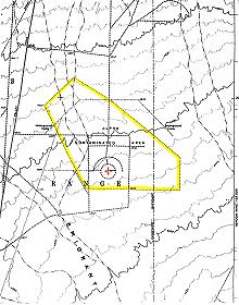
 This map shows the location of Project 57 ground zero (GZ) and the fence surrounding the Alpha Contaminated Zone. |
To protect workers at Area 13 against the hazards of plutonium inhalation, personnel were required to wear full protective clothing with all openings taped to their skin and full-face respirators with high-efficiency filters. Heavy respiratory protection made breathing difficult during hard physical labor. Supplied-air respirators were used during the biomedical study program. These provided positive pressure inside protective clothing so that any leaks would be outwards to prevent contaminants from entering the suit. After the extent of hazardous conditions in the test area was determined, workers were given the option of wearing supplied-air respirators or full-face filter respirators. As restrictions were further reduced, half-face respirators with high-efficiency filters were adopted for areas with less than 100 micrograms of plutonium contamination per square meter. All participants in field activities for Project 57 received bioassay tests to check for exposure to plutonium. These tests consisted primarily of nasal swabs and, occasionally, urinalysis.
Once members of Task Group 57 had mapped the extent and distribution of the remaining plutonium contamination within Area 13, the contaminated zone was fenced off and posted with signs denoting Internal Radiation Hazard to unprotected personnel. Warning signs were also posted at the equipment burial trench, approximately 300 feet west of the "No. 36 Marker" on Valley Road. The Project 57 site lay abandoned and nearly forgotten for almost 20 years as nearby Watertown (designated Area 51 in June 1958) grew into a thriving clandestine flight test center.
 Map illustrating radioactive contamination levels within the fenced section of Area 13. |
In 1981, the Department of Energy Nevada Operations (DOE-NV) sought funding through the Surplus Facilities Management Program (SFMP) for the decontamination and decommissioning of Area 13. The application for funding was submitted by Arden E. Bicker of REECo. In the application, Bicker describes Area 13 as being "approximately five miles from a public road and directly adjacent to the site of a rapidly growing military installation." In fact, the contaminated zone was located just east of Valley Road, which is the primary thoroughfare from Area 51 to the town of Rachel in Sand Springs Valley to the north of Area 13. The "public road" described by Bicker was the road to Groom Mine. Three years later, the road, the mine, and most of the Groom Mountains were seized by the Air Force to prevent public access, and provide additional security for Area 51.
The Review Board discussed the fact that Area 13 was off-site from the NTS, on the Nellis Air Force Range. Presumably then, it might be the responsibility of the Air Force to decontaminate the site (or leave it alone). Also, the Board wondered if it was even appropriate to include a parcel of contaminated ground in the SFMP since it was not actually a "facility" per se.
The Review Board's most pressing questions were rooted in the "Requirements for Acceptance" portion of the SFMP Facility Acceptance Procedure, the rules and regulations for inclusion in the SFMP. These requirements stated that "the facility shall be in a radiologically safe condition." Specifically, a current radiation/contamination survey of the facility and surrounding area had to be available, structures and monitoring equipment had to be adequate to contain and monitor any radioactivity, and security systems and procedures had to be adequate to prevent unauthorized entry. The Review Board was very concerned about these points.
At the time of the original application for SFMP acceptance, the most recent radiological survey of Area 13 had been taken in 1977. Results were reported only for land within the 895-acre contaminated zone. The Board took issue with the fact that "additional Pu migration within the site since the time of the 1977 survey, and dispersal of Pu outside the site boundaries were not discussed in the DOE-NV request." The application had also stated that "minimal DOE surveillance is being performed at Area 13 because the contaminated area is not within direct control of DOE." The Board held off on accepting Area 13 into SFMP, stating that "with the limited information available, the board was unable to assess the current radiological safety of Project 57."
The Board made several recommendations to DOE-NV that would allow the Project 57 site to meet the guidelines for SFMP funding. A new radiological survey was required to determine the extent and migration of plutonium from the fenced contaminated zone. A hazards analysis had to be performed, with particular emphasis on assessing the predicted radiation exposure of workers at the new construction site. DOE-NV had to determine an acceptable concentration level for plutonium in the soil (for any levels detected after the cleanup). The Board also required that DOE-NV provide a description of safety measures that would ensure that plutonium would not continue to migrate off-site.
Next, heavy equipment was to be procured for the excavation of contaminated soil. Four 30-ton ore-haulers and one earth-mover were to be purchased for $1,250,000. A water-well was to be drilled for dust suppression support in order to prevent resuspension of plutonium into the atmosphere. Actual decontamination was set to begin in January 1984, with an initial effort to remove 40,000 cubic yards of soil. Estimated expenses for FY-1984 were $2,500,000.
Three more 30-ton ore-haulers and a 5,000-gallon water tanker were to be purchased in FY-1985 to support the removal of an additional 90,000 cubic yards of soil. Total costs for FY-1985 were estimated at $2,500,000. The plan called for removal of 100,000 cubic yards of soil per year from FY-1986 through FY-1991 at an annual cost of $2,500,000.
However, cleanup of the Project 57 site was still a concern during environmental studies in the late 1990s. A preliminary site characterization was completed in 1998 and a complete assessment of plutonium cleanup was scheduled for FY 1999. According to Steve L. Hoeffner et al (Clemson University-Research Park) and Richard Smalley (Waste Policy Institute, Savanna River Research Campus) in Evaluation of Remediation Methods for Plutonium Contaminated Soil, "a limited amount of data is available for the Area 13 soils," and cleanup of the site is a "low priority."