 |
Even though class had started, I couldn't quite keep my hands off the hunt. Every few weeks, I'd pull out my huge collection of aerials and peer at them again under high magnification, hoping for some sort of divine inspiration.
There was an obvious progression on how I searched the photos. When I first got them, I naturally looked for the most blatant scars. That's how we found one of the other crashes out there. But then, when those were ruled out, I had to turn to subtler indications. These all turned out to be natural soil colorations or rock outcroppings. Still, my lack of success caused me to ratchet down what I'd consider as a possibility.
One of these real minor things had to do with a stream channel I spotted on one of the photos. It was just your ordinary channel, in the middle of a wash. What made it stand out ever so slightly, was how smooth and gradual it flowed, much like a road. No abrupt little jags, just smooth curves. Following it downstream, it finally split up into smaller, parallel channels. That seemed a little odd, as normally stream channels join and get bigger, they don't fragment into smaller ones.
Under high magnification, I thought I saw something else out of the ordinary (I couldn't be sure because of the quality of the print). It looked like before the "channel" came to an end, there was another steam channel coming in from a side canyon and joined it. What was odd about that was that it looked like they joined in a U turn. My vast engineering background told me water just doesn't flow that way.
I had ordered some negatives of the area taken in 1957, to use as a "before" comparison. While the resolution of these negatives wasn't real good, it didn't appear that the stream channel I was looking at in my 1968 photos existed on the 1957 photos. This was really getting my attention now.
One of the perks of being a student (other than checking out all the young babes on campus) was access to a do-it-yourself photo lab for B&W prints. I took my 8" aerial negatives over to the lab, and after a lot of futzing, enlarged the crap out of them. This "U turn" was looking more suspicious, but I was still concerned it was wishful thinking on my part. The only way to know for sure was to actually check the site. Sigh....another trip.
This locale was remote enough and devoid of distinguishing features that I thought it would be best to just figure its GPS coordinates and hike in using those. To do that, I had to transfer the spot from the photos to my USGS topos and measure the lat/long. No problem, I thought.
It turned out to be more difficult than I had anticipated. Even though the wash was clearly visible on the photos, I couldn't seem to find it on the map. I finally had to use triangulation from other spots on the photo whose corresponding points on the map I could find. What I found was that what appeared to be a reasonable sized wash with a stream channel on the photo, was only a minor, insignificant ravine on the topo map. What made this unusual was that there didn't appear to be enough watershed to create a channel of the magnitude I was seeing. Of course, there was the possibility the topo maps could be wrong, but it could also be the what I was seeing as a stream channel was actually a road.
Fortunately, I had a rare lull in class intensity around this time, so on April 4, 1997, Jeri and I shot out to the middle of Nevada to check this out. I tried not to be hopeful about it, but that seldom works. We camped in a remote spot for the night, and planned to hike in the next morning. This was to be a cross country jaunt, and I was depending on the GPS to get us there.
The next morning, April 5th, we started off early, using the GPS and a compass. Soon, the truck vanished in the distance as we went up and down, across the undulating terrain. I made a note of the compass back bearing in case the GPS died on us. Finding the truck again could be a real problem, as all this terrain looked the same.
We reached a high spot just over a 1/4 mile from where the GPS told us our destination lay. I saw a few ravines, and locked on the what looked like the likely one. But checking with the GPS said the one we wanted was at a different bearing. Oh yeah, that small, indistinct one over there. Did I transfer the coordinates right?
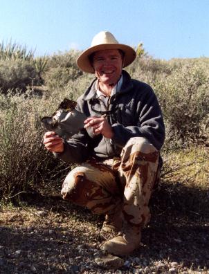
Just as I started down the slope, I froze. There at my feet was a piece of metal! I'd recognize the luscious, smokey color anywhere, and instantly knew what it was...a piece of 928's titanium skin.
It was here!
 |
Or, at least it was somewhere close by. I looked around and didn't see any other pieces. The spot we were heading to was still a distance away, so maybe this was debris splatter. Still, I very carefully noted where I found the piece and we continued to our main target.
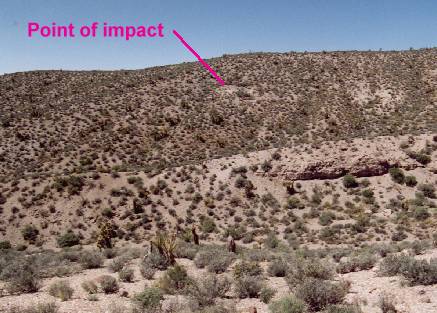
As soon as we got into the little ravine, I could see traces of an old road. That's what I had seen on the aerial photo and thought was a stream channel. Walking up the ravine, we came upon debris scattered everywhere. As one who helped in the search put it, "The long national nightmare was over". The quest was at an end...the grail had been found...Elvis has left the building...uh, no, not that last one.
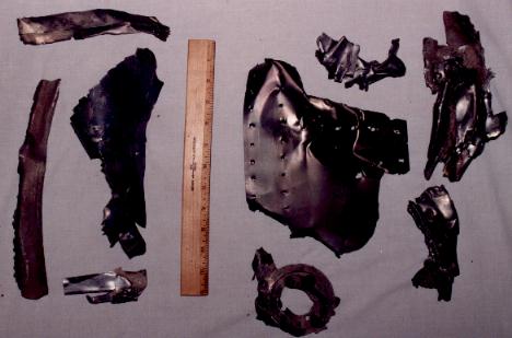
By watching the density of debris, we formed the outline of the impact area in our minds. It was less than 100 yards wide, but perhaps 200 yards long. It seemed as if 928 impacted in this small ravine in a tail-down orientation, but with it's nose still pointed in the direction of motion. And it hit hard. We were able to find a gouge where it appeared the tail struck the ground, but other than that, there was no scar, or evidence of fire. It was amazingly indistinct. You couldn't see this until you walked right up into the debris field. In an earlier foray through the area, we had passed within 200 yards of the edge of site and had not seen a trace! Strangely, in the middle of the debris field there were yuccas still standing, with shards of titanium in their spikes. Normally, I'd expect them to be flattened, why they weren't I don't know.
 |
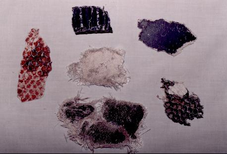
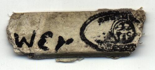
The largest piece of debris was only maybe 10" long. This was all pretty small stuff, and all the large items had evidently been hauled away. Even so, there is great quantities of small, well shredded titanium everywhere (the A-12s were over 90% titanium). There were a lot of hydraulic lines and plenty of an interesting composite material. This composite stuff was part of the early attempts at reducing the radar signature of the craft. It looked like a cross between asbestos and fiberglass, and a lot still had black paint on it.
 |
 |
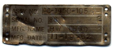 |
 |
 |
Near the center of the debris field, we found evidence of the military encampment. Not quite as messy as I expected, but still lots of aluminum food trays and rusted beverage cans strewn about.
After a while, I just sat and stared at it all. It was satisfying in a way I can't begin to articulate. It was also somewhat eerie knowing we were the only people that had been to the spot in 30 years. We had closed the circle and finished the story. We had Walt Ray's impact site, and now 928 itself.
Being on-site, I was interested to note that the remote viewing attempt now seemed pretty unreliable. While the terrain somewhat matched the description, the manner of impact certainly did not. It wasn't a shallow impact and it didn't appear that any engine separated and went into an adjacent ravine. Final score: Remote viewing, 0...Perseverance, 1.
After a few hours we slogged back to the truck and headed for home, with a warm glow. I made a few phone calls and passed on the coordinates to those who helped in the search. Over the next few weeks, the site was visited by two other parties. As a measure of how indistinct the spot is, one party had the spot marked on a map, as well as the GPS coords. Their GPS died, and in spite of it being marked on a 7 1/2 minute USGS topo, they spent much of the morning looking for the right ravine.
In early June I made my second, and probably last trip to the site. It was a solo trip to range out from the impact site to see if any larger pieces could be found. The other two parties failed to find anything large, and the largest piece I had was the very first one I came across. I found that the debris was all localized in the ravine 928 landed in, with the exception of a small area of splatter almost 1/4 mile away, at a right angle to the impact. In a burst of amazing luck (things just have a way of working out, don't they?) it was through this area Jeri and I first approached the site. I found a few other reasonably sized pieces of skin, but nothing quite as large as that first, special piece.
There may be other treasures remaining out there. There were two cameras, perhaps a foot long, attached to the inside of the canopy. Five days after the crash, the canopy was found just over a mile from Ray, but the cameras had separated during descent, and apparently were never found. A lot of time was spent by men on horseback looking for them, but seemingly to no avail. Have lots of free time?? Want something that eluded the massive forces of the US government? Go to it....but that hunt is far too hopeless for me! I've learned my lesson.
So you think you might want to try and find this neat bit of aircraft history, eh? Good luck! After all the crap I've been through to find this damn thing, do you think I'd just come out and tell you??! I've dropped plenty of clues in this narrative, if you've been paying attention. It may take time and effort on your part, but if you really want it, you can find it. A few last hints:
Useless statistics:
A Final Thought:
Something that occurred to me goes back to one of the original stupid reasons for chasing after this. There are any number of stories out there of crashed UFOs. If you buy all of them, then the damn things must be falling out of the sky everywhere. Something that's always been in the back of my mind (and probably many others) is "Wouldn't it be fun to try and track down one of these things?" Well, after investing all this effort into searching for a terrestrial (although very spacey looking) craft, I'm pretty skeptical that any remnants of an actual saucer crash (assuming one really occurred) could be found. I was dealing here with an event I knew had occurred, which had a reasonable amount of documentation, was in favorable, open terrain, and proved nearly impossible to find. If a saucer ever did plop down somewhere, I suspect not a trace would remain. Still, it would be more fun than hunting snipe....