A Grand Aerial Circumnavigation of Area 51 (March 10, 1996)
by Tom Mahood
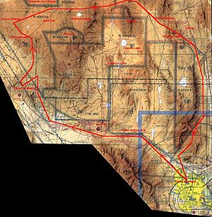 This is the account of an aerial circumnavigation of the Nellis Range made on March 10, 1996. The pilot for this strange excursion was Will Seiber, who was on spring break from the University of Oklahoma, and was visiting the Las Vegas area with some friends. Normal college students go to Florida, Palm Springs or Mexico for spring break, but the real fun, twisted ones go to Area 51. Will arranged the rental of a Cessna 182 for the adventure, and Glenn Campbell and I went along as ballast, in case the turbulence started tossing the plane around.
Click in the preview on the right for a large the map of our route. But be warned it's a large jpg image, over 220k. However it is plotted on an FAA chart of the area, showing the various restricted airspaces, so some might find that information of interest.
We departed the North Las Vegas airport about 7:00 am and started to climb, following Highway 95 to the northwest. The air was smooth and quite clear, with visibility in the 80-100 mile range. Just a perfect day for what we had planned.
Exactly what we had planned was a traverse of R-4807A, the restricted airspace south of the Tonopah Test Range and north of the NTS and Groom airspace. This was the airspace that opened up in July of 1995, allowing civilian air traffic on Sundays when the military had no Flag exercises planned. This certainly demanded a look. Will had taken the precaution of checking with the local FAA Flight Service Station before we left, to ensure there wouldn't be any surprises. Hah!
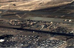
Indian Springs AFB |
Shortly after we passed Indian Springs AFB at 8500', we got a nice look at Groom Lake from the south, and an even better view of Papoose Lake. Due to the vibration of the aircraft, the viewing of details was no better than the further distant Mt. Stirling location on the ground. Still, it was a pretty sight.
Passing Mercury, we had a good look into the Test Site, with Frenchman Flat and Yucca Flat spread out very fine, with CP-1 perched on its ridge between.
Continuing northwest along Highway 95, we had a good peep at Area 27, which used to be the assembly area for the various devices detonated at the NTS. There were a number of smaller buildings there, but were a bit distant to see any details. Next, we came abeam of the Jackass Flats area. The BREN Tower and all the old NERVA facilities and MX missile test deployment areas were easily seen, as well as the portal area of the Yucca Mountain project.
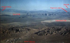
Frenchman Flat and Yucca Flat in the Nevada Test Site |
As we reached the area between Yucca Mountain and Beatty, it was time to head due north into the formerly completely restricted R-4807A airspace. We came to the conclusion that it would probably be a good idea to be in touch with Nellis Control for any warnings of nearby aircraft, so Will gave them a call on the radio. Nellis came back right away and told us we were in restricted airspace and to immediately turn to a heading of 270 degrees (i.e., west) and exit the airspace. Get the hell outta Dodge!
Well, THAT was certainly interesting, not to mention unexpected! After turning to the west, we looked at each other, then looked at the map then asked Nellis if they were sure about that? Nellis responded with a terse "yes!" Then, Will read to the controller that part of the aircraft sectional chart where the new restrictions for the area were listed. It didn't seem to impress the controller in the least. Nellis said the area was CONTINUOUSLY restricted!
We quickly tried to decide what to due next. Even if this controller character had his head up his ass, we weren't about to violate instructions and proceed through a restricted area. Not healthy, these guys have aircraft with guns, and they certainly know how to use them. Will thought it best to land at Beatty and make a phone call or two (all of us completely forgetting the presence of Glenn's beloved cellular phone in the back seat).
As we turned toward Beatty, Will got back on the radio and asked for Nellis' phone number so that we might give them a call from the ground, which the controller gruffly provided.
This must have hit a nerve, because just a few minutes later Nellis came back and informed us that we were cleared to enter R-4807A. Musta been a new guy who finally checked with his boss!
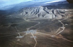
Tolicha Peak Electronic Combat Range (TPECR) |
With that weirdness out of the way, we headed back north toward the twin radomes on Black Mountain. As we approached it, the Tolicha Peak Electronic Combat Range (TPECR) came into view just to the west, so we detoured over to have a look at that.
I had previously seen the facility from Stonewall Peak, but from a direct overhead viewpoint it looked much less substantial. No airstrip, but a lot of expected radar and other electronic emplacements. At the main facility area there were several aluminum warehouse type buildings with large rollup doors. Access was via a paved road from Highway 95, which continued on to the radar facilities atop Black Mountain.
All in all, not extremely impressive and certainly not a secret saucer base! Which I suppose was exactly what they wanted us to think. We were playing right into their hands.
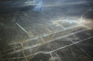
"Korean Airfield", used for target practice |
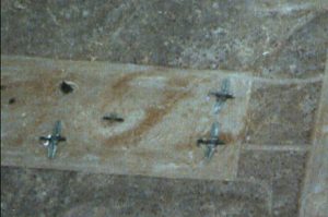
Junked planes on "Korean Airfield" |
However, just a bit further north from the TPECR was what looked like a large desert airstrip with a number of aircraft on it. Now that was worth a look, so we proceeded over to it and circled. It turned out it was some sort of target area made up to look like an airstrip, with a collection of junked planes on it. We found out later that this site is called the "Korean Airfield", laid out to simulate a typical airstrip of, well,...the North Koreans. Just what you'd expect to find in Nevada.
Some of the aircraft had their wings detached from the fuselages and placed next to them on the ground. None of us could quite figure out just what kind of planes they were, although there appeared to be an assortment.
About this time, we must have been really annoying Nellis, because the radio crackled back into life and Nellis wanted to know "What your intentions were?" Well, we couldn't very well say we were looking for secret saucer bases, so Will diplomatically replied that we would be heading east toward Rachel. Nellis came back and instructed us to proceed toward Rachel without delay. We got the impression that civilian planes don't do this too often and they weren't going to relax until we were out of there.
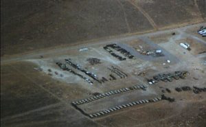
Tanks, waiting to serve as practice targets for aircraft |
So we started east, marveling at all the weird targets, bomb craters and various pieces of junk out there. In one location there was looked like a giant dirt parking area for all sorts of armored personnel carriers and perhaps tanks. It was likely a storage spot for potential range targets. Of course we were also keeping our eyes open for the secret saucer bases, but this being Sunday, they were apparently closed.
We checked out the Gold Flat area, a potential location for the Cheshire Airstrip (but that's another story), and saw nothing.Just desert and bombed areas.
As we were cruising east at about 9,500', we had a look into the Tonopah Test Range to the north. Its boundaries were fairly apparent due to the perimeter road used to access the cinetheodolites. The main base area of TTR was too far north to make out many details.
Unfortunately we didn't get too good a look into Area 19 of the NTS, as our route was a bit north of it and we picked up a bit of sun glare looking south. While we could have turned south and followed the border more closely, we were a bit nervous already at being where we were. Nellis had come back on the radio several times to warn us we were approaching the southerly boundary of TTR, so they might have freaked had we turned directly toward the NTS.
But while we might have been nervous, the Nellis boys seemed even more so. At one point they asked what our final destination was going to be (Are they going to be meeting us, we wondered??) and Will described out route back to Las Vegas. Nellis replied "Sightseeing, huh?", to which we could only agree.
I noted, with more than passing interest, the antics of our plane's transponder. The transponder flashes a light on the instrument panel whenever it's interrogated by a ground based radar. Normally, it flashes briefly every few seconds or so. In this area it was illuminated almost constantly! We were certainly being scanned a lot and I wondered if the light would burn out.
After passing just north of the appropriately named "Saucer Mesa" (strictly due to its shape!!) we crossed over the Kawich Valley just north of Kawich Lake. The lake had what appeared to be a giant bullseye in it, with a pole at its center. Don't know what it was.
Slowly, we could see Rachel and the normal world approaching off in the distance. But better than that was a choice view of Groom Lake looking right down the two runways to the south. The west runway still looked to be definitely the longer of the two. We were far enough from the main base so that we really couldn't pick up details, but we observed that the dirt road accessing Groom from the north (Rachel) is paved after it passes through the guard gate. So much for the idea that all really fine secret bases must be at the end of a dirt road.
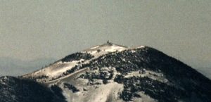
Bald Mountain |
After passing out of the restricted airspace, we collectively breathed a sigh of relief and headed for Rachel. We made a few low passes over Rachel to check things out. It looks about as forlorn from the air as from the ground. Getting bored with that, we turned south, flying over the Tikaboo Valley. We had hoped to get a good view of Bald Mountain and the facility atop it, but after cheating death by crossing the restricted area, we decided to keep our distance and never got a really good view due to aircraft vibration.
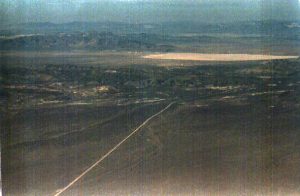
Groom Lake and Area 51 |
On the other hand, the view of Groom from high above Tikaboo Valley was nothing short of spectacular. From our vantage point there were no foothills to block the view, so the whole facility sprawled before us. From our height, even Papoose Lake was visible to the south. That view was worth the trip alone, and we weren't even in restricted airspace anymore.
Turning a bit to the east to skirt the remaining restricted areas put us right over Tikaboo Peak. It certainly looks flatter from the air. Don't understand why the hike is so hard. There was minor snow and looked to be hikable as of the time of our flight.
The rest of the trip was almost noneventful. I say almost because as we continued south over Highway 93, we needed to contact Las Vegas approach prior to entering the controlled airspace which surrounds the Las Vegas area. After several minutes of wondering why they weren't responding to our radio queries, we realized that the transmitter in our aircraft wasn't working! That was just swell. Will wisely brought along a hand held aircraft radio as a backup, but it appeared we were too far out to make contact with the lower powered radio.
Will decided the best way at this point was to drop below the lower ceiling of the controlled airspace and slither our way back to the North Las Vegas airport. Perfectly legal, but we were unable to be anymore than 2,000' or so above the ground. It's situations like this where the engine usually starts to make funny noises, but this time it behaved itself. Finally, with the airport in sight, Will was able to raise them on the handheld and we plopped back down with an exquisitely smooth landing, just after 10:00 am, three hours after we left. The folks at the rental agency seemed to think the problem was simply that the microphone plug was pulled out slightly, but Will had checked that possibility several times in the air. Personally, I think it was all those electronic countermeasures we flew over. Anyway, disaster averted.
All in all, an outstanding adventure and lots of fun. I'd highly recommend it for any aircraft buffs or anyone with interest in the NTS/Nellis area. I don't know that I'd do it again, as there just wasn't a whole lot to see, other that what we did see. It was certainly an itch I wanted to scratch.
The photos, quite frankly, suck. I mis-set my exposure meter and most of mine turned out very poor. Glenn and Will had better luck, but we were all shooting through the lousy plexiglass windows of the plane. I had not yet learned the trick of removing a single retaining screw on a Cessna's window frame, enabling it to open all the way up to the bottom of the wing. In this mode, Cessna's make great inexpensive camera ships. So there still is the potential to do the trip again and return with some excellent shots.
Send comments to: Tom Mahood, tmahood@ibm.net
© Copyright 1999-, Dreamland Resort. All rights reserved. Copyright Policy Privacy Policy Page last modified 08/04/2018
 This is the account of an aerial circumnavigation of the Nellis Range made on March 10, 1996. The pilot for this strange excursion was Will Seiber, who was on spring break from the University of Oklahoma, and was visiting the Las Vegas area with some friends. Normal college students go to Florida, Palm Springs or Mexico for spring break, but the real fun, twisted ones go to Area 51. Will arranged the rental of a Cessna 182 for the adventure, and Glenn Campbell and I went along as ballast, in case the turbulence started tossing the plane around.


