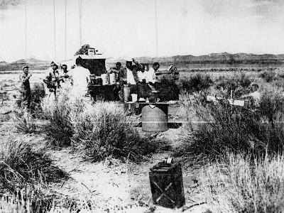
The recovery crew takes a break during clean-up operations at the crash site. From left to right: "Wiggie", Jerry Carney, Benedict Koziol, Glen Fulkerson, unknown, unknown, unknown, Paul Lehan, unknown (seated).
On 11 May 1997, Tom Kinzel and I drove from Pioche toward Lund to start our search for the U-2 crash site. We began by crossing the dry bed of the White River near Sunnyside, and proceeding south to the big wash that I had seen in the aerial photos. When we arrived, I was startled to find that the wash was rough, hummocky, and completely overgrown. It did not seem like a safe place to land light aircraft, or even a helicopter. I drove out onto the wash for a few miles. It was rough going. When I finally stopped to compare the surroundings with the photo, I saw that nothing matched in any direction.
We continued to drive east over rough terrain for about another mile, then parked and proceeded on foot. We walked almost to Whipple Reservoir, occasionally checking the photo. Still nothing matched. After returning to the Jeep, we drove back toward the road. Although the scenery didn't match the photo, there was one small peak on the horizon that looked familiar. I thought maybe it was the right mountain range, but seen from the wrong angle.
We headed north and then southeast toward Camp Spring. Again, we were met with frustration. We finally drove back to Sunnyside to query local residents. Most seemed too young to remember the incident. We finally found an elderly woman who looked like she might have lived in the area for some time. Unfortunately, she had moved there some years after the accident and had no knowledge of it. The photo remained our only clue.
Next, we drove south to an area with several reservoirs called Murphy Meadows. Here, the riverbed was wide, flat, and overgrown with green grass. As we crested a ridge, I looked back and was startled to see a familiar horizon. It was just like the photo, but from a higher angle. Of course! The meadow made a perfect natural landing field for small aircraft. Here, the riverbed was wide and made a bend to the east so that the crash site could indeed be "south of a big wash" as described.
I drove down into the meadow. At the edge of the riverbed there was a wide swath of coarse vegetation. It looked like the foreground of the photo and the horizon to the east matched the background of the photo. I soon found that the relative nearness of the horizon made it easier to match the photograph. Any slight deviation changed the scene dramatically. I soon located the recovery crew's campsite using the photo and found some rusty tin cans on the ground. At least I knew we were in the right area. Now I had to locate the impact site.
Tom and I began a random search of the area on foot. This haphazard approach produced no results. We had wasted most of the day pursuing dead ends and dusk was approaching. Clouds moved in and obscured the sun. Still, we found no trace of the U-2. As rain began to fall, I realized that we would have to give up our search. We planned to stay overnight in the town of Rachel, nearly a hundred miles away by road. We drove away frustrated, knowing that we had been very close to our goal.