Tonopah Test Range (TTR)
 Tonopah Test Range (TTR) and its surrounding remote facilities are located approximately 30 miles south-east of the town of Tonopah, Nevada. From Tonopah, take Hwy 6 eastbound until you get to the famous TTR sign. A large rocket, reminding of the original purpose of TTR as a ballistic missile test range, points down a paved road towards the main base.
TTR is managed by Sandia National Laboratories. It has some connections to the Department of Energy, to the Air Force Flight Test Center (AFFTC) at Edwards AFB, CA and of course to the nearby Area 51, which is a detachment of the AFFTC.
The main facility of the Tonopah Test Range can be seen in the distance from several spots along Hwy 6. But for a much better view you will have to drive down the main access road for almost 20 miles and climb one of the hills dotted around the area. Mount Diablo in particular has a great view of TTR from only a few miles distance.
One good thing about this base is that it has very frequent visitors. Almost daily you can see a B-2 Spirit, B-52H, B-1B or F-117s and other aircraft doing tests above your head. Some tests go on for hours. If no aircraft are flying, there may still be weapons trials going on in the valley around TTR. Early mornings and late in the evening you can see the 'Janet' Flights going in and out of the base. These are mostly Boeing 737-600's used by workers at TTR and Area 51 to commute to their workplace from Las Vegas each day.
The large main base complex is separated into several secure areas. Extensive hangar areas are prominent in the northern part of TTR. These hangars are arranged in twin rows, referred to as Canyons, parallel to the long runway. The rectangular area around the canyons is a high-security area, surrounded by a double fence. Aircraft taxiing between the Canyons and the runway have to pass through an automatically operated double-barrier. The Canyons were built in the early 1980's to house a squadron of F-117 Stealth Fighters during their top-secret tactical evaluation here at TTR. During their operational phase, after being unveiled to the public, the F-117's were then stationed at Holloman AFB, NM. In 2008, when most of the F-117's were decommissioned after more than 20 years of service, they returned to the Canyons at TTR for storage. Some fly out of TTR on a regular basis as of 12/2019.
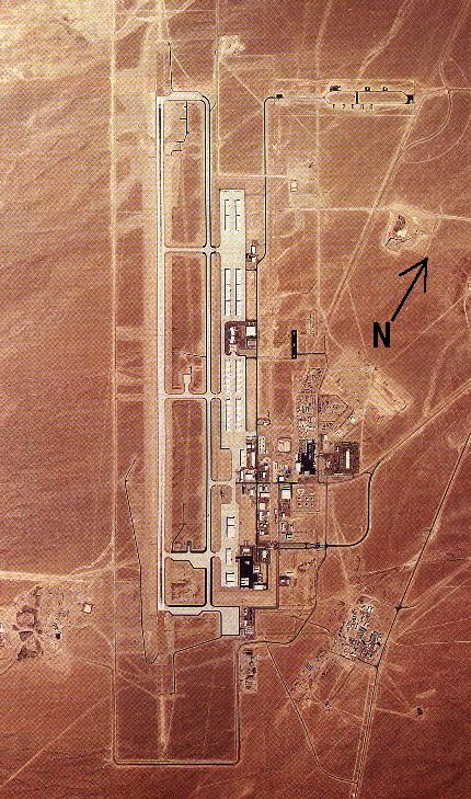
Aerial view of TTR. The double-rows of hangars with white roofs, dotted parallel to the runway, are the F-117 hangars, known as 'Canyons'. In the top right hand corner is the explosives storage area. Image source: Tom Mahood.
|
| |
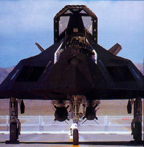
This photo clearly shows the Security Gates behind this F-117A at Tonopah Test Range. These gates are located at every Taxi-way turn off to the F-117 hangars; something not even found at Area 51. This is mainly because TTR has frequent uncleared visitors participating in tests and exercises, such as Red Flag. Photo: Randy Jolly.
|
|
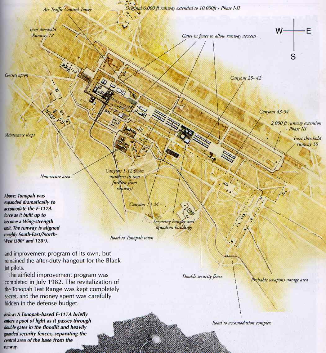
This map of TTR in 1983 clearly shows the secured area, where aircraft taxiing to/from the runway have to pass through gates, as mentioned above. Scan from "Jane's: How to fly and fight in the F-117A Stealth Fighter". Note: The N-S orientation as shown is incorrect; the top of the map is roughly south-west, not north.
|
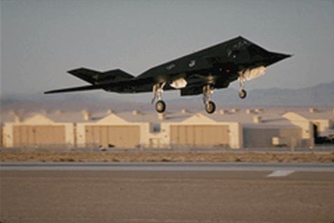
F-117A taking off from Tonopah Test Range, with the Canyons in the background. Image from "Jane's: How to fly and fight in the F-117A Stealth Fighter"
|
| |
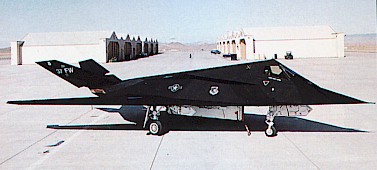
F-117A taken when still based at Tonopah Test Range with the Canyons behind the aircraft. Image from "Jane's: How to fly and fight in the F-117A Stealth Fighter".
|
|
Ballistic Missile Testing
The base is primarily used for testing and tactical evaluation of aircraft weapons systems, but also serves as a base for Sandia Labs to conduct ground based weapons trials. Sandia Labs design and test warheads for future and also current weapons such as the famed 'bunker busting' bombs used in the 1991 Gulf War and the 'Allied Force' conflict in Serbia and Kosovo.
Fitted around the base and the vast ranges of TTR are cameras, radar sites, seismic monitors and other sensors. These sensors are not for monitoring curious tourists around the perimeter, but for monitoring weapon trials inside the range. Sandia Labs do a lot of missile, rocket and bomb trajectory tests using aircraft, MLRS Launchers and SP Guns.
The aircraft you see flying in the TTR Ranges and MOA's (military operating areas) are quite likely on a flight test for a new weapon or warhead or maybe for trials on avionics. Dotted around the Ranges are lots of 'bulls eyes' used as targets for air-to-ground weapons. The JDAM was tested here as well as other large bombs.
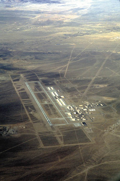
Photo of Tonopah Test Range taken by Mark Farmer (Agent-X) in an Aggressor F-16 backseat over the Nellis Range complex. The Photo is shot from the south looking due north. This image is copyright ©2000 by Mark Farmer (Agent-X). No reproduction or copying of any means is authorized without permission of the author. All rights reserved.
|
| |
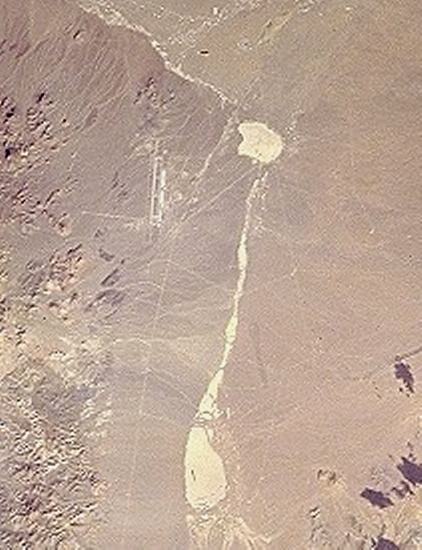
Tonopah Test Range and the surrounding area. The two dry lake beds are Main Lake in the north and Antelope Lake in the south. The area between the lakes is Cactus Flat. Image Source: NASA. From the Space Shuttle.
|
|
Electronic Combat Ranges around TTR
Outside of the Base itself, on the vast ranges of the TTR is an area/facility called 'Site-4'. Site-4 is part of the TECR or Tonopah Electronic Combat Range. This Range is used by the USAF for Training pilots against Electronic warfare such as Surface-to-Air Missile (SAM) threats, AAA threats and also Electronic Counter Measure and Electronic Support Measure (ECM and ESM) training. Dotted around the base are real threats, including many actual Russian made systems such as SA-6 SAM's, ZSU-23-4 AAA systems and other Russian, Iraqi and Eastern European systems. Site-4 is owned and operated by the 554th Range Squadron, which has its Headquarters located in the center of the site.
Tonopah ECR operates in conjunction with Tolicha Peak ECR (TPECR) located Southwest of TTR. Tonopah ECR as well as Tolicha Peak ECR are also used by Tonopah Test Range, Area 51 and Edwards AFB for testing stealth aircraft against real-time threats such as the foreign systems mentioned above. The Stealth capabilities of the aircraft are tested by flying the aircraft over the threats to see if the enemy radar can detect it.
The SAM and AAA Radar are not the only radar systems to avoid. Also used at the ECR's are EWRS or Early Warning Radar Systems. These are the 'real' threats that in a conflict need to be disabled first, because many EWRS can actually detect Stealth by changing tracking/scanning frequency and modes. These radars can pass information to the smaller targeting radars, to give away the Stealth location, enabling them to make a "kill".
Another use of the ECR sites is during Red Flag. These aerial war-game exercises are operated out of Nellis AFB with some deployments actually operating from the TTR base itself. During Red Flag, U.S. and allied pilots are trained in extremely realistic aerial combat situations, including the enemy systems of the ECRs.
|
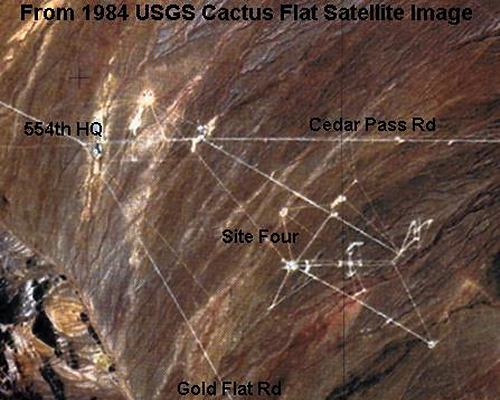 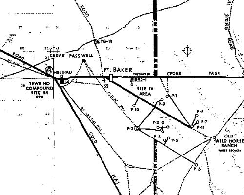
This image shows the 554th Range Sqn HQ (TEWR HQ on the map) and some of the surrounding radar sites and threat simulators. As can be seen in the map, the TEWR HQ has a helicopter pad, but no runway. This site is located east of TTR, between Cactus Flat and Cedar Pass. Image source: Tom Mahood
|
© Copyright 1999-, Dreamland Resort. All rights reserved. Copyright Policy Privacy Policy Page last modified 12/22/2019