Nellis Based Exercises
This page describes in some detail the various exercises held each year at Nellis AFB in Nevada using the extensive Nellis Range Complex. All Text is Copyright ©1999. Richard Cliff. All Rights Reserved.
Described Below are :
RED FLAG - complete with Red Flag viewing points in chart below
AIR WARRIOR - complete with MOA information
MAPLE FLAG
FRISIAN FLAG
Red Flag Exercise:-
To see a chart/map and a good description of where to view the exercises, click here : Nellis Range Chart / Info
Its best to use the chart after you have read the below article:
Red Flag is currently the most realistic simulated air-warfare exercise held anywhere in the world. Held at Nellis AFB many times each year it provides NATO and Allies the best air-warfare environment to train in.
Red Flag is administered by the Tactical Fighter Weapons Center at Nellis which also runs the Air Warrior exercises. Air Warrior Exercises will be described later on this page.
Red Flag has two players, the Blue Team which are Allies and the Red Team which are the Enemy.
The Blue Team involves the NATO and Ally nations which are tasked with defending and attacking.
The Red Team involves the very experienced pilots of the Aggressors who fly F-16 aircraft with special camouflage to mimic Russian and Ex-Warsaw Pact Country Camouflage.
The Red forces start the day over in the West side of the ranges, southwest of Tonopah while the Blue Force starts out south of Caliente. They all 'meet' in sectors i have described below, generally around the area west of Rachel and south of Warm Springs.
The Actual area reserved for military flying in Red Flag is over 10,000,000 acres of which over 3,000,000 is the actual Nellis Ranges. The Range has over fifty different types of targets which include Trains, Armored Vehicles, Industrial complexes, High threat targets such as Radars, SAMs and AAA placements, convoys, railways and bridges and also complete airfields. Some convoys on the Northern Ranges are believed to be over 17 miles long incorporating every type of vehicle NATO would come up against. Complete Railways of over 10 miles long with complete Trains are placed on the northern ranges and also the industrial complexes are very large multi-building areas. All high threat simulators such as the Radars are soviet made and operate on the exact frequency they would in time of war detecting inbound aircraft at ranges over 250 miles relaying target information to the manned stations.....it is all extremely realistic.
Red Flag is held over the whole Nellis Gunnery and bombing Range Complex and also in the large Military Operating Areas(MOA) designated 'Desert MOA' and 'Reveille MOA'.
The Nellis Range and MOA's are split up into sub-sections which are the following:-
- Tonopah Electronic Combat Range(TECR), which is centered around the Site 4 complex within the Tonopah Test Range. This is the main electronic combat range with manned high threat simulators. Within the TECR are many simulated threats such as SAM Sites, AAA placements, Fire-control and Acquision Radars, and of course the Tonopah Test Range Airfield (from where the F-117 was operated when it was still a Black Project).
- Tolicha Peak (TPECR), which is located around the Tolicha mountain and incorporates a mock 'korean' designed airfield with many mothballed aircraft located there as targets. Around the airfield and ECR are many other AAA and SAM Sites but these are much more limited than those used at TECR. Tolicha Peak is mainly used for Interdiction strike missions of which most simulated threats are used here for that mission such as those mentioned above. Tolicha Peak ECR is located on the West side of the Nellis Ranges.... Near-by is the Black Mountain Target Acquision Radars used as threats and targets.....two of which are located at the summit.
- Electronic Combat Range South Sector, which has much more limited threats than Tolicha Peak ECR. This range is primarily used for training pilots to use the Anti-radiation missiles such as HARM at SAM and AAA Radars. It too has many threat simulators. Like the ECR's mentioned above, these are primarily used in regular training.
- Range 61, 62 and 64, used for bombing and gunnery training and also used for simulated Nuclear bomb delivery training.
- Range 63, used also for Live bombing and gunnery training at day and night times and also used for CAPSTONE Live firepower Demonstrations and various delivery techniques.
- Range 65, used for daytime conventional bombing and gunnery training.
- Range 71, 74, 75 and 76 are all used for Live and Dumb Bombing and gunnery training on high value high threat targets such as AAA, SAMs, Industrial complexes, Radar sites, Trains, Convoys and other high value Military targets such as Bridges.
- Dart East, Dart West and Dart South are used for live and practice air-air engagements with guns and missiles.
- Desert MOA The Desert MOA is further divided into sub sectors which are:-
- Caliente Sector
- Alamo Sector
- Reveille Sector: This also comes under the Reveille MOA.
- Elgin Sector
- Cedar Sector
- Coyote Sector
All of the above sectors are used for air-air training and are all used for Subsonic and Supersonic interceptions, Dogfights and General handling..... Flight Levels used around the Desert MOA in the sectors mentioned above range from 100ft Above Ground Level(AGL) to 50,000ft AGL. These sectors are extremely busy during Red Flag. Sonic Booms can be heard throughout the day in these areas from low level to high level.
- Reveille MOA borders with the Desert MOA and is located North of the Desert MOA around the Reveille Peak Area...near Cedar Sector of the Desert MOA and of course Reveille Sector!
- Nevada Test Site is used for Red Flag also, but very limited. Aircraft are not allowed to pass through below 15,000ft and are to avoid the Groom Lake area completely. Reading a document found on the DoE Website, An overflight of Groom Lake is only allowed for emergency use only and HAS to be above 15,000ft. Although selected pilots from Nellis are allowed to fly over and even land here when tests are not being carried out.
The Red Forces:-
The Red Forces are made up of the 414th Combat Training Squadron based at Nellis. Their F-16s use a variety of paint schemes to great effect in providing camouflage over the desert. Schemes include :-
| Lizard Cammo | Brown and Tan Color in Wrap around scheme |
| Ghost Cammo | Gray and Blue Color Scheme |
| Patches | Four Shades of Blue |
| Silver | All Metal Finish Scheme |
| Snake | Green, Brown and Tan color scheme |
All Aggressors have soviet style numbers on the nose such as Red 25 or Blue 76 etc.
Participants on Blue force have been extremely varied and alot are not even NATO members but are allies to NATO and the USA. These include over the years since the 70s:
- The United Kingdom which is a major player in All Flag and Air Warrior Exericses using Tornado GR-1 and F.3, Jaguar, Harrier, VC-10 Tankers, C-130(special forces), AWACS and TriStars(tankers) and have come home with many Bombing and ECM trophies.
- Venezuela using F-16s
- Netherlands using F-16s
- Norway using F-16s
- Australia using F-111s
- Denmark using F16s
- South Korea using F16s
- Egypt using various types
- Germany using F-4s and Mig29s
- France using Mirage2000s
- Singapore with F16s
- Belgium with F16s
- Greece with Mirage2000s and F-4s
- Italy with F-104s
- Jordan with F16s
- Turkey with F16s
- Thailand using ??
- Saudi arabia using F15s
- Spain using F/A-18s
- Not to mention USAF, USN and USMC using near enough every front line aircraft in US inventory.
A typical day of Red Flag is made of two or three 'wars' each day. One in the morning, one in the afternoon and sometimes one at night. Each Blue force sends up approximately two to four packages, each containing up to 20 to 30 aircraft. Each battle lasts for 2 to 3 hours.
There are four Red Flags per year, and each Red Flag has one to three 2-week periods with different players. So, each Red Flag is 2 to 6 weeks in total. In each period a few days are set aside for Special Operations such as Combat Search and Rescue, Airdrops and Transport exercises using the C-130 , C-160 and many Helicopters.
Before each Flag mission, special orientation flights are set up by Nellis so that unfamiliar pilots can get an overflight of the ranges, names of places, altitudes, etc. These are usually done in C-130 Hercules and UH-60 Black Hawks.
Aswell as Nellis, Tonopah TR, Wendover AAF(Utah), Indian springs and other small airstrips are used.
Tankers are provided by Beale AFB and other participants such as the Royal Air Force who provide VC-10 and TriStar Tankers for those who have the hose and drogue system such as the USN and USMC.
AWACS is provided by Tinker AFB and also participating countries such as again, the Royal Air force who bring a very advanced E.3D Sentry.
The big bombers such as the B-52H and B-1B do start each sortie at Nellis although some missions involve the bombers operating from their home bases of which maybe over 1000 miles away. This gives them a chance to practice long range missions.
Threats on the ranges are very realistic. For instance so-called 'Smoky SAMs' are placed around the northern ranges. When an aircraft is approaching they fire upwards to the aircraft with a smoky trail, and at night a flare can be seen at the base of the rocket to add more realism. Unfortunately, there is no way to simulate a 'wall of lead' from AAA fire(tracers). High threat targets and simulators involved are vehicles and structures such as:
The ZSU-23-4 and ZSU-23-2 'shilka' AAA Vehicles. These are very deadly Soviet-made anti-aircraft weapons.
SA-3, SA-6 and other Soviet-made SAM launchers together with radar systems such as Flat Face, Long Track and other surveillance systems.
All aircraft involved in the exercises are equiped with a special pod which is located on one of the hardpoints.
This pod is vital in the fact that it gathers data for ground personnel to be able to 'see' what's going on in the theatre of battle.
The Pod is called an 'AIS' or Airborne Instrumentation SubSystem. This attaches to the pylon like a Aim-9 Sidewinder or ASRAAM and is linked to the aircraft's on-board electrical, avionics and weapons systems. This pod then communicates directly with special systems located in ground stations, or if over the sea, located in buoys. These are called the Tracking and Communications SubSystem(TCS).
These are then in turn linked with Ground Based Stations which act as a 'master' TCS system. From here the feed is transmitted via microwaves to the computer and computed Subsystem (CCS) based at Nellis. All information gathered comes up on large screens and the personnel are then able to 'see' what the pilots are seeing, where the bombs drop, what the situation is in the 'air-war' and so on. This System is used on all ACMI Ranges such as that located at Deccimommannu in Sardinia and that of the British Aerospace ACMI Range located in the North Sea.
All pilots and crew involved are then, after landing, debriefed via the DDS (Display and Debrief SubSystem) to view their actions, wins, mistakes and so on.
For more detailed information on these ACMI systems please read our Red Flag ACMI Information article.
For viewing Red Flag, the Desert MOA sectors mentioned above are the best places. Specifically around Cedar, Coyote, Caliente, Reveille and Alamo you will see good air-war 'action'. This includes Rachel, which is located in the Coyote Sector where most of the Air combat takes place.
Below are a few photos taken around the ranges and surrounding areas.
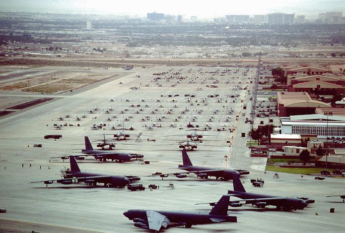
Official USAF Photo by Nellis AFB.
A hive of activity at Nellis AFB, Air Combat Commands largest airbase. In this photo you can see B52H, B-1B, F/A-18s, F-15s, F-16s, A-10s, F-4s and quite possibly RAF Tornados. Right down the end pointing towards the runway is an F-15E with an F-16. At this time of year when Red Flag is 'on', every type of front line US Aircraft is on the ramp including many other aircraft from NATO and Allied Countries.
A vastly different operating procedure to that of most UK and European airbases of where you hardly ever find a decent flightline with all aircraft 'hiding' in their Hardened Aircraft Shelters (HAS) or Mountain shelters.
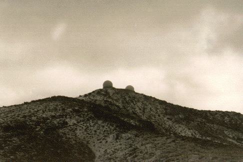
Photo: Official USAF Taken by Nellis AFB.
Black Mountain Radar Station. These act as targets and threat simulators which serve as a Target Acquision Station. Located not far east of Tolicha Peak.
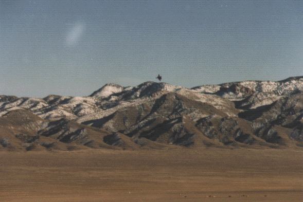
Photo: Official USAF Taken by Nellis AFB.
An F-16 banks hard or could possibly be 'jinking' to avoid retaliation from the targets below his aircraft at the bottom of the photo. This was taken out on Range 74 where many of the Nellis Range targets are located including most of the high threat simulators.
In the mountains out of view could quite possibly be a Forward Air Controller (FAC) designating and 'calling' in the aircraft for support. FAC's main 'weapon' is the Laser Designator which he aims at the target such as a building or tank. This beam then lets of an arc of light at which the incoming aircraft then drops its laser guided weapons. The weapon then 'rides' the laser beam for pinpoint accuracy even on moving targets.
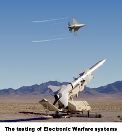
AFFTC Photo
An F-16 banks hard streaming vapor from the wingtips as it evades the SA-2 SAMs located on the Nellis North Ranges around Tolicha Peak and Site-4 of TTR.
Official USAF Photo Taken by Nellis AFB.
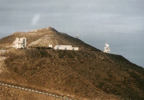
Antelope Peak high value high threat simulator. The radar on the left is a FAN SONG radar, which is used with the SA-2 (above).
Official USAF Photo Taken by Nellis AFB Personnel.
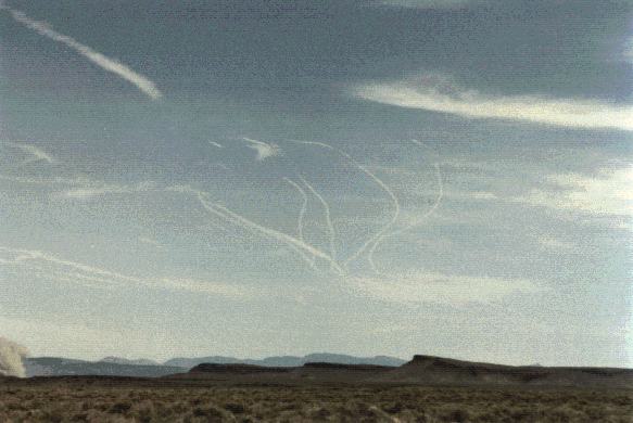
Fight is on!....a few fighters above the ranges turning and burning. During the exercises the sky is filled with these contrails with usually just one noise of a jet...as they all mix together. Then that noise is usually disturbed by a loud Sonic Booooom!
Official USAF Photo.
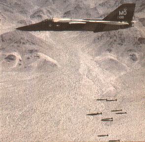
An F-111 formerly based at Mountain Home, Idaho dropping Mk82 bombs. From the background this looks like either Range 64A or possibly Range 63? Need verification on this. It also could be during CAPSTONE. Perhaps Nellis could verify when they take a look at this!
USGS Photo.
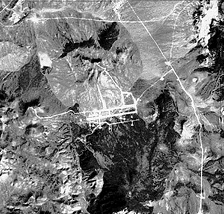
Tolicha Peak 'Korean' airfield. A major Red Flag target and also used during day-to-day training. It has many different types of AAA, SAMs and aircraft on the field.
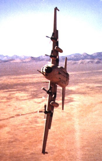
Photo courtesy of Paul Geary.
An RAF C-130 banking over hard for the camera about to do a 'wing over'! This variant is the RAF Special Forces insertion Hercules which performs similar duties of that of the USAF MC-130 Combat Talon. It is identified as a SF 'Herk' by looking at the wingtips...each wing tip has a ECM/ESM pod.

Official USAF Photo.
Recently the German AF has been attending Red Flag with their aquired Mig-29 Fulcrums. A very rare visitor to the USA as German AF F-4 Phantoms are the usual visitors. German AF Fulcrums doing air-air combat are usually seen doing so either over the North Sea in the British owned ACMI Range or the NATO Decci Range in Sardinia. German Mig-29 pilots give good practice to NATO pilots for DACM (Dissimilar Air Combat Manoeuvering).
Seen here over the Nellis Ranges are two examples of the German Migs together with 2 examples of the Nellis based aggressor F-16s. The German Mig-29s are based at Laage AB in Northern Germany.
Official Nellis AFB Photo.
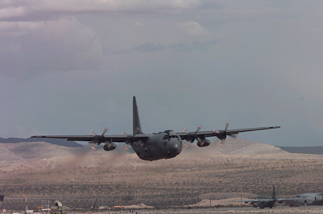
What looks like an RAF C-130 lifts off from Nellis AFB to go enroute to the ranges. In the background on the ramp is another C-130 and a C-17.
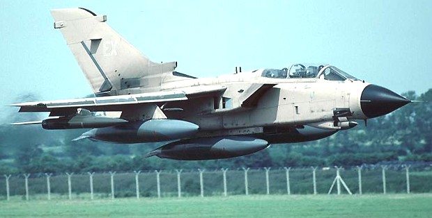
Photo: RAF.
A RAF Tornado GR-1 as low as you can go. Literally 'mud-moving' in the UK like this example over an airfield, but found 'sand-moving' in Nevada and California quite frequently. If Tornados are not at Nevada, you'll find them at China Lake along with other RAF fast jets such as Jaguars and Harriers for months at a time! A frequent winner of the Bombing and ECM trophies for Red Flag.
Over Saudi Arabia, video footage shows RAF Tornados actually 'meeting' their shadows on the floor and at one point, four aircraft had to rise to go above camels and nomads. In the Red Flag, height around the Desert MOA is down as low as 100ft which is ideal for the Tornado crews as they feel at 'home'. Over the Ranges they go much lower and much faster.
Official Nellis AFB Photo.
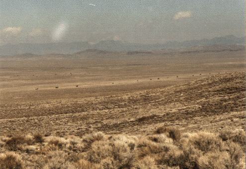
A Convoy target area out on the ranges. You can find these on the ranges near Hwy 95 also. As mentioned some convoys on Ranges in the northern end of the complex extend as long as 17 miles.
Official Nellis AFB Photo.
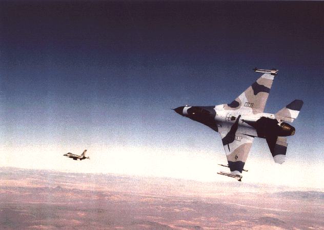
Two of the Nellis based aggressor F-16s in the famous aggressor camouflage. These are the 'Reds'. The nearest aircraft is carrying two AIM-9 Sidewnders on the wingtips with an AIS pod used for ACMI on the outer hardpoint.
Official Nellis AFB Photo.
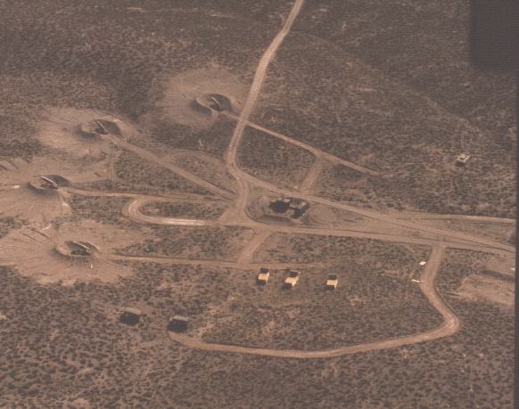
A mock SA-3 guideline SAM Site. Something Allied Forces came up against in Serbia and Iraq. A very potent weapons system! These are usually deployed in dug-out positions and there are usually over 4 placements. The center object is the Radar and Fire-control system. Other vehicles look like support trucks in the bottom of the photo, and a ZSU-23-4 in the middle right hand side.
In almost all cases, the radar is located at the center of the 'fan' of SAMs that spread out. Primary targets here for any attacking force would not be the SAMs but the radar and ZSU-23-4. Once the radar is 'knocked out' the SAMs are useless, only then would the SAMs be a target as secondary depending on how many aircraft and what weapon used. Cluster munitions would make mince meat of the whole area but the
Shilka would need taking out first. Other ways is to just use a HARM on each of the radar and Shilka.
Air Warrior:-
Air Warrior is also held at Nellis AFB and is 'played' almost all year round inbetween Red Flags. Air Warrior however does not use the Nellis Ranges. This is because Air Warrior is primarily a Close Air Support (CAS) Exercise held in conjuction with the Army, Navy and Marines. The Royal Air Force also plays in these exercises as they do in Red Flag.
Air Warrior is mainly centered around the Fort Irwin National Training Center in Eastern California which trains ground units the art of battlefield tactics and is indeed a Red Flag for the Ground Force with extremely realistic warfare with up to 400-500 vehicles at any one time.
Air Warrior is the air component of this, providing CAS, Attack, Diversion, top cover and so on. As well as the Ft. Irwin Ranges, Air Warrior also uses the Shoshone and Owens MOA, as well as others. Death Valley is also used as a refuelling area and 'run-in' area.
Air Warrior provides very good training for CAS pilots which fly the Harrier, A-10 and F-16CJ. Helicopters are also used extensively here as well as the 'Aggressors' found at the Flag exercises. China Lake NAWC (NAWS) is also involved providing its ranges to the air component. This is because China Lake's Eastern Range borders with Fort Irwin. Aggressors here may also come from the nearby 29 Palms Marine Corps Base located south of Ft Irwin as well as the Nellis based aircraft.
Worthy of a mention here also is NAS Fallon located near Reno in Central Nevada. NAS Fallon took over from NAS Miramar in the training of Navy pilots in dogfighting and the art of air-warfare. This is more famously known as TOP-GUN.
TOP-GUN also have their own Aggressor Squadrons and probably play a role in Red Flag seeing as the USN take part in these exercises. Fallon based Top-Gun pilots may also use the MOA and Ranges of Southern Nevada. However, central Nevada does have extensive MOA's assigned to TOP-GUN and the Air-Warfare Center at Fallon.
For the coordinates of military operating areas used during Air Warrior, please see our page with Military Operating Area (MOA) Coordinates. The page is extremely useful if you do not have an air-chart handy. You can plot the co-ords yourself in long-lat format. It also tells you what height the aircraft are allowed down to.
Flag exercises outside the United States:-
Maple Flag:-
Maple Flag as you may guess is held in Canada. The exercise is administered by Red Flag Personnel. Main participants in this exercise are Canada, USA, Germany and UK. Much of the UK's Low Level Night operations are in Canada anyway at Goose Bay, Labrador. The RAF are strong competitors in Maple Flag as they are in Red Flag.
Centered around CFB Cold Lake in Alberta with much of the ranges centered around the weapons range of Primrose Lake to the North East. The actual range where the exercises takes place is 100x40 miles and is virtually all flat with a few trees providing Allied Crews a very difficult task of running-in without getting seen.
Much of the environment is very similar to Northern Europe so this is why you'll find many European NATO countries involved. The area surrounding Cold Lake is virtually uninhabited so it is ideal for fast low-level exercises.
The ranges have the same threats as Red Flag such as AAA, SAMs and armored convoys although these are placed on flat uninterrupted areas presenting a real challenge to mud movers.
The exercise is very similar, with Red and Blue forces undertaking much the same sorties as Red Flag except a change of scenery. The change of scenery is vital however to many countries especially to the Royal Air Force and United States Air Force Europe. This is because the Desert of Nevada presents no challenge to RAF and USAFE Low Level flying operations. These guys are trained in the art of terrain following and flying over the desert and in european Camouflage is not good training. The same goes with A-10 CAS Pilots. Many of the operations involve tree top cover... Nevada hasn't got many trees so training for this is absolutely useless in Red Flag. This is why Maple Flag represents more of a challenge to the mud-moving pilots... Flying at 100ft and over 450kts in their own element instead of the desert with no cover.
As well as the strike, CAP and escort elements, CSAR is also a major factor in Maple Flag as it is in Red Flag.
Pilots who are 'shot' down and splashed are later apparently flown out to the simulated impact point and left there to do a bit of survival training until the CSAR Package is able to get to them. All realistic stuff!
Frisian Flag:-
The last type of Flag exercise is the Frisian Flag. Held in the Netherlands this utilizes the Dutch Ranges as well as fighting over the North Sea. Something Red and Maple Flag don't have: Lots of water with no cover!
NATO and Allied forces again play Red and blue forces. This Flag exercise is smaller than the others but still incorporates a lot of what the others have in the way of targets and air-air combat. This Flag exercise however is on a much smaller scale and is mainly for European forces although last year USN F-14s, EA-6Bs and F/A-18s participated, and of course the USAFE Based F-15 and F-16 units in the UK and Germany.
Air-air Refuelling is done in the many AARA (A-A refuelling areas) in the North Sea owned by the RAF, USAFE and the Dutch. The Paderborn range and several others are used for weapons and Nordhorn, located just inside the German border and owned by the RAF, is also used. As well as the Flag held in Holland, European air forces train against targets such as those at Red Flag every day also.
The largest electronic combat range in Europe is located in the Spadeadam Range on the border of England and Scotland. This is a very sophisticated range and also has a mock airfield, high threat targets and threat simulators. One difference though is that Spadeadam is located in forests and very hilly areas making it a very realistic exercise area. Even more so than the Tolicha Peak ECR, mainly because it is located in an area that is more likely to be the same as that in a war zone such as Serbia. The landscapes are very alike and Nevada only presents a challenge if you are going to fight in the desert of the middle east.
The UK has a NATO low flying system second to none. With minium altitudes of 250ft over most areas of the UK with designated training areas down to 100ft it presents a real challenge to any pilot. It is said that most USAF pilots that train in the UK never want to leave due to the freedom of movement at low level and the challenge of the mountains, hills and valleys. However the ranges are very small in comparison to those in America!
The Dutch Flag and Canadian Flag exercises present a perfect environment for operations in the Balkans theatre.
As well as these flags, day-to-day operations over the UK, Holland and Germany train pilots much the same as they do in the Flag anyway apart from the high threat simulators.
© Copyright 1999-, Dreamland Resort. All rights reserved. Copyright Policy Privacy Policy Page last modified 09/11/2007


