Aerial photos of Edwards AFB South Base
Edwards South Base uses the same runways as the main base but it is located on the other side of the runways. This gives it some "privacy" within an already secure base. South Base is another highly secure facility that is rumored to house the mysterious RQ-180 UAV. This clearly is a very active part of the base. No less than four new hangars were built there since the last available satellite photos were taken in 2015.
Scroll down or click here for historic information about Edwards South Base from Aviation Historian Peter Merlin.
The great aerial photos below were taken on Sunday, 10/24/2021 by a photographer who wishes to remain anonymous. We like to thank the anonymous supporter for allowing us to share these great close-up photos.

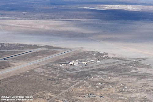
Overview of Edwards South Base, looking north-east with Rogers Dry Lake in the background. The main runway 05R/23L is on the left. Highway 58 is barely visible in the background.
|

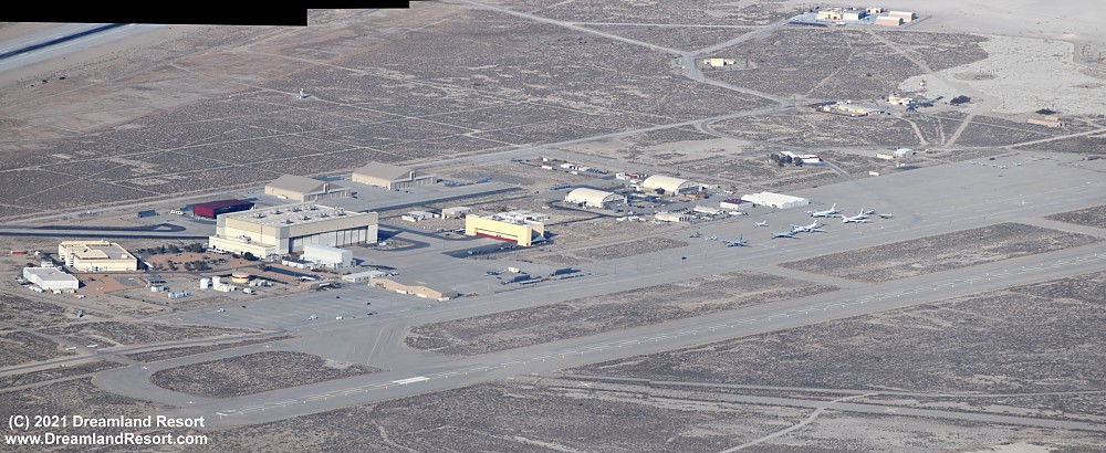
A closer look at the South base ramp. The largest hangar was used for the Boeing Airborne Laser project. Its current use is unknown. The two hangars and the red shelter behind it were built between 2015 and 2021. The lower double hangar in the front is also new, probably built in 2019/2020. The small aircraft in the far corner of the ramp are of the Edwards Aero Club.
|

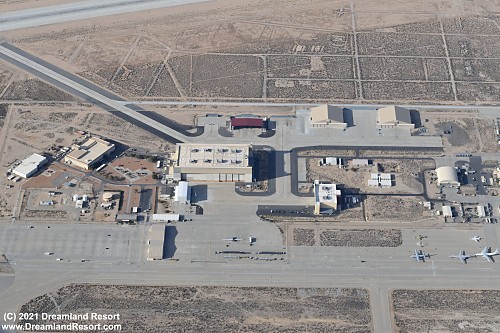
Two more closer panoramas of the main ramp area from different angles. What looks like the shape of a UAV under the red shelter in the photo above turns out to be a scaffold in the photo below. Aparently the shelter is currently only used for materials storage.
|

The shape of the concrete walkway in front of the administrative offices resembles the shape of the B-2. Coincidence?
Notice the absence of taxi lines to the Airborne Laser hangar and to the smaller new double hangar. There are however taxi lines to the two larger new hangars on the right. Is this where the mysterious RQ-180 lives?
|

Close-up of the airborne laser hangar and the two new hangars behind it
| |

Another close-up of the Airbornse Laser hangar and the administrative complex
|

NATO RQ-4D Global Hawk sitting on the ramp in plain sight
| |
 |
Edwards South Base History
By Peter Merlin
In 1933, Army personnel from March Field established a modest tent camp on the east shore of Rogers Dry Lake, six miles east of Muroc, a small community that had been settled in 1910 adjacent to the Santa Fe railway, whose track bisected the lakebed. The Army built targets on and off the lakebed, including a moving target on a track, simulated structures and naval ship outlines. Obsolete Keystone bombers served as targets, as well. In 1935, a second tent camp was established on the west shore of the lakebed, just one mile north of Muroc. The skies above the ancient playa soon echoed with the throb of piston engines as Army pilots bombed and strafed the desert in all manner of aircraft, from the diminutive Boeing P-26A Peashooter to the Martin B-10. The camp population fluctuated according to the size of visiting squadrons and only 13 Army personnel from March were needed to operate the range. All this was about to change. In the summer of 1941, America was on the brink of war.
In July 1941, more than 100 troops arrived by train and immediately began work on a new Army camp less than two miles south of Muroc that was initially used by Maj. George V. Holloman as a test site for two Douglas BT-2 trainers. These airplanes had been modified with radio control systems in a highly classified project that paved the way for future robotic-weapon development.
Immediately following the Japanese attack on Pearl Harbor on December 7, 1941, personnel and aircraft from the Army’s 41st Bomb Group and 6th Reconnaissance Squadron arrived at Muroc for crew training. Two days later, four squadrons of Martin B-26 Marauders deployed to the desert base for two months of coastal antisubmarine patrol duty. As the base population grew to 40,000 personnel, the tent camps were replaced with permanent buildings, hangars, barracks, and all attendant infrastructure. Facilities included a control tower and the first concrete runway at the desert site. On July 23, 1942, Muroc Army Air Field became independent from March Field.
In the spring of 1944, the Army’s Manhattan Engineer District designated Muroc AAF as “Site M” and commenced a series of more than a dozen ballistic drop tests of dummy atomic bomb shapes. At least four of these were the little-known Thin Man uranium-gun type weapon. The rest were the Fat Man plutonium implosion bombs. Due to ballistic instability the Thin Man was eventually abandoned in favor of a more conventional shape dubbed Little Boy. These test shapes were all dropped on targets scattered across the old Muroc bombing range east of the lakebed.
In April 1946, the Army Air Forces ended training activities at Muroc and the base on the south end of the lakebed was merged with Muroc Flight Test Base at the north end of the lakebed and designated a research and development center. The complex was renamed Muroc Air Force Base on February 12, 1948, following establishment of the U.S. Air Force. Test operations commenced immediately, ushering in what many consider the most dynamic era in aeronautical history. The U.S. military soon began a rapid transition from propeller-driven aircraft to jets, and virtually all Air Force and Navy prototypes were evaluated at Muroc. At the same time, a joint project of the military and the civilian National Advisory Committee for Aeronautics (NACA) was begun to explore transonic and supersonic flight phenomena with the Bell X-1 and Douglas D-558-1 and D-558-2. The NACA Muroc Flight Test Unit was designated a permanent facility on September 7, 1947. The name was changed to the High-Speed Flight Research Station in November 1949.
In December 1949, Muroc became Edwards Air Force Base, named in honor of the late Capt. Glen W. Edwards following his death in the crash of an experimental flying wing bomber prototype, the YB-49A. Construction of a new Main Base complex began in 1950, and included construction of a 15,000-foot concrete runway. The old training field became South Base and Muroc FTB became North Base, both serving as auxiliary landing strips. Eventually, the railroad tracks were rerouted north of the base perimeter and the entire lakebed was designated an airfield with 16 unpaved runways marked on its surface. The longest stretches seven-and-a-half miles, making it the longest runway in the world. Consolidation of Air Force flight test activities continued with relocation of the Air Materiel Command Experimental Test Pilot School (later renamed the U.S. Air Force Test Pilot School) from Wright-Patterson Air Force Base to Edwards. The NACA High-Speed Flight Research Station moved from South Base to the northwest corner of the lakebed in June 1954, where it eventually became the NASA Flight Research Center.
The South Base auxiliary airfield retained many remnants of the early days of flight-testing including loading and fueling pits for the Bell X-1 and McDonnell XF-85, hydraulic jacks used to raise B-50 mother planes for mating experimental aircraft, a cruciform thrust stand for anchoring jet and piston powered airplanes, and a static firing stand for rocket planes. In 1964 NASA conducted a series of flight tests of the Lunar landing Research Vehicle, a high-fidelity flying simulator for the Apollo lunar lander. During the 1980s a secure compound was constructed at South Base for the Northrop B-2 stealth bomber. Eventually named the Birk Flight Test Facility, this ultimately became a hub for testing bombers, unmanned aerial vehicles, the YAL-1 Air Borne Laser testbed, and other projects.
© Copyright 1999-, Dreamland Resort. All rights reserved. Copyright Policy Privacy Policy Page last modified 05/22/2024


