Hi-Res Aerial Panoramas of Area 51 from all directions, December 25, 2020
The photos below were taken on Christmas Day 2020. The Ranges were "cold" and the pilot requested and was granted permission to fly from south to north across the R-4806W airspace. More specifically he flew from Mercury across Ranges 65D, 65C, 65B, 65A and 61A into the Coyote Alpha and Coyote Charlie MOA. From there he headed south across Range 74A and EC South. In doing so he flew almost a full circle around R-4808A, the Area 51 air space that is off limits even to military pilots. Luckily for us he had his camera handy and took the super hi-res panoramas below, showing Area 51 from ALL SIDES!
While most panoramas show Area 51 from the east, the easiest accessible side, photos from the other directions are very rare. This page, showing Area 51 from all sides is an internet first, revealing parts of the base that are normally hidden from view.
All photos were taken 12/25/2020. Publication with friendly permission from the pilot. Click images to enlarge. Scroll down for a peek under the scoot-and-hide shelters.

Area 51 seen from the South, looking down the main runway. This is the angle Janet pilots in approach to Area 51 see the base.
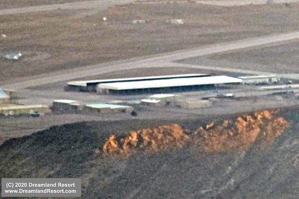
The two scoot-and-hide shelters around hangars 20-23 are clearly visible. The south ends of both shelters have partial siding further shielding from view what is on the ramp they are covering. A view screen covers the open bottom part of the long side facing the runways. Clearly the project moving into hangars 20-23 requires a very high degree of secrecy.
The 2009 hangar that was damaged a few years ago is completely gone. Some equipment in its old location could indicate upcoming new construction at that site.
There is a small building next to the earth berm east of the 2007 hangar that is not visible from the Tikaboo view spot.
From this angle the 30 base housing buildings in the center of the base are easy to make out.
There is clearly something under the scoot-and-hide south of Hangar 19. Impossible to tell though what it is.

Area 51 from the South-East.

Area 51 from the East. This angle offers a great view of the center of the base and the north ramp on the right. As in other recent photos there are no helicopters parked on the old heli pads north of the ramp. If we rule out the possibility that they are equipped with a new cloaking device it is likely they are now parked inside one of the large hangars at the North Ramp (hangars 4-7)

Area 51 from the North, looking at the base across the Groom Lake dry lakebed. The road in the foreground left is Groom Lake Road to the guard shack and eventually to Hwy 375.

Area 51 from the West. The area with some trees in the foreground left is a man made lake, known as Slater Lake after former base commander Hugh "Slip" Slater. The lake served for recreational activities in the 1960's and 70's. Today it is surrounded by classified installations, mostly Russian radar sites, and access to the area is restricted. From this angle we can see that the west side of the new scoot-and-hide shelter, at least for now, is not covered with siding.

Enhanced close-up of the scoot-and hide shelter west of hangars 20-23. It is still open on the long side, revealing a fairly narrow spacing of the support beams on the side facing the South Ramp area. This leaves only the north side open and further indicates a fleet of small aircraft moving into the hangars. |
|

This close-up of the southern extension of hangar 19 shows some sort of gray object under the shelter. It looks like a large vertical stabilizer of an aircraft but due to the shadows and distance it is hard to tell. |
© Copyright 1999-, Dreamland Resort. All rights reserved. Copyright Policy Privacy Policy Page last modified 05/21/2024


