Area 51 Satellite Image, August 23, 2011
Below are some clips from our new 2011 Area 51 Satellite image, taken by the GeoEye-1 satellite on Tuesday, August 23, 2011 at 11:23am PDT. The resolution of the original image is 0.5 meter, making it the highest resolution and most up-to-date satellite image of Area 51 ever published.
There is evidence of two major new construction projects just getting under way, one major construction project and a couple of smaller ones being wrapped up and major road improvements. It certainly looks like Area 51 is busier than ever, and getting ready for new black projects which, although we are curious, we agree must be kept secret to ensure the safety of our country.
The individual clips show significant changes since our 2009 Satellite Image. Click in the preview images for a full 0.5 meter resolution version of the clip. Some of the clips are quite large. You may need to disable automatic image resizing in your browser settings.
This is a Dreamland Resort Exclusive! This new satellite image was taken upon our request, and paid for with donations from our readers. All photos are © 2011 Dreamland Resort and GeoEye. Publication of this material outside of the Dreamland Resort web site is strictly prohibited.
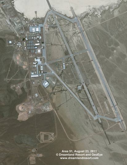
Overview of the entire main base area. Click in the preview above for a 2 meter high-resolution version. |
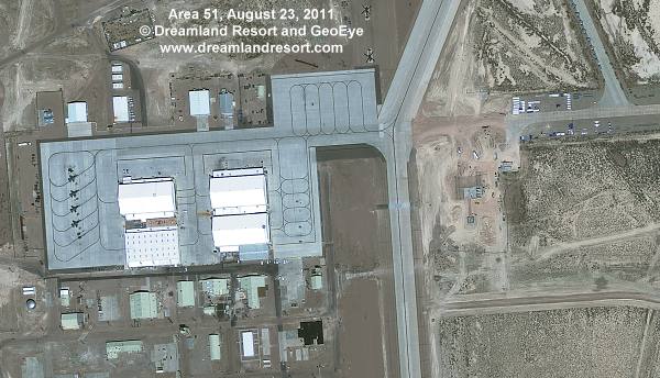 There is some very interesting construction at the north end of the base, just east of the North Ramp. It looks like the construction of yet another new hangar in its very early stages. It is interesting to note that this new hangar would be the first hangar east of the old U-2 runway, which now serves as taxi way. There is some very interesting construction at the north end of the base, just east of the North Ramp. It looks like the construction of yet another new hangar in its very early stages. It is interesting to note that this new hangar would be the first hangar east of the old U-2 runway, which now serves as taxi way.
The size and distinct shape of the foundation of the new hangar looks very similar to two existing hangars at Nellis AFB, near the north end of the base. The hangars at Nellis are used for the security helicopters. With the Groom helicopter ramp being just north-west of the new construction (two helicopters can be seen in this frame) it is very likely that this hangar will also be used for the PaveHawk security helicopters.
The clip also shows four F-16 on the North Ramp. Finally, one of the buildings belonging to the block of the original U-2 hangars, the one in the north-west corner, has been slightly extended to the north. The U-2 hangars all have light green colored roofs. The extension has a white roof. |
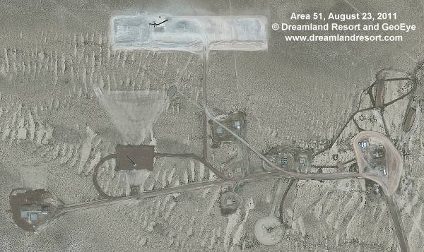 This remote site just north of the road from Area 51 to Gate 700 to the NTS was expanded around 2006. Not much is known about the purpose of the site. It may be a specialized RCS test site, or otherwise used for radio tests. There was not much evidence of activity here for a while, but our new satellite photo shows lots of fresh tracks at the eastern cell of this complex. There is also a newly developed area north of the existing site that appears to be a gravel pit. There are fresh tracks from the gravel pit to the cell in the east, but no further tracks on the only access road. The gravel pit appears to be designed to support a faily large construction project, so it can be expected to see the construction of a good size new facility around the exisiting site in the near future.
 |
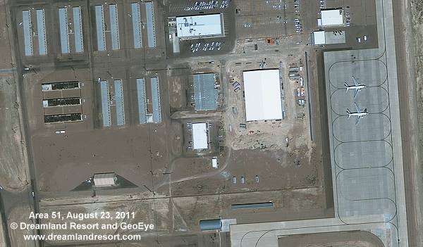 A new very large building is under construction just east of the Janet ramp. It measures approximately 255x184', and appears to be fairly tall. Nearby buildings include, counter-clockwise from the Janet ramp, the Janet Terminal, the New Base Headquarters, the PMEL Lab and the Main Security building. The building is large enough to be a new hangar, but based on the location near the new Base Headquarters it is more likely a new Dining Hall and/or administrative offices. The latest Google Earth imagery dated 6/28/2010 shows the previously vacant area being graded in preparation for the construction.
Another, smaller building was added south of the dormitories, along the road leading to the security building and to the construction site above. It looks somewhat temporary and may be related to the construction. |
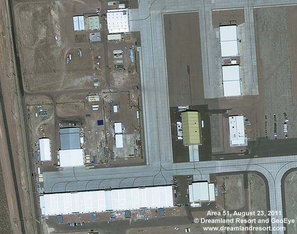 Another large hangar was added at the South Ramp between 11/05/09 and 05/24/10. Ground preparation for the foundation can be seen in our June 29, 2009 Satellite Image. The hangar is located just west of the old Hangar 20-23 storage building. It is connected to the ramp on the south side, opposite another hangar that was added in early 2005.
 |
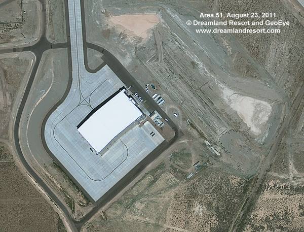 Construction of the ramp around this large new hangar built on the far south end of the base seems to be finished. We discovered construction of this hangar from Tikaboo on June 10, 2007. The hangar appears to be operational, and there is no indication of any further construction in the vicinity in the near future.
There has been much speculation, but it is still not clear what project "lives" in this hangar. There has been no convincing explanation for the location far away from the other hangars, for the orientation in an angle to all other buildings at the base, or for the berm of dirt east of the hangar. It has been suggested that it is to block the view from Tikaboo, but it seems that a simple view screen would have accomplished the same. |
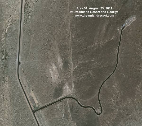 In December 2009 we reported that the visible section of Groom Lake Road inside the boundary had been paved. In August 2010 the Back Gate Road was re-paved, including a section of the road on public land that had been a dirt road before. Not surprisingly the new satellite image shows that some of the access road inside the restricted area have been paved as well. The newly paved roads include Groom Lake Road, the Backgate Road, the road to the engine test cells on the far south end of the base and the access road to a fairly new radio site on a hill on the north-west side of Groom Lake, which is shown in this clip. We discovered the new site on June 1st, 2008, but we still do not know much about it.
 |
This page contains material (C) by GeoEye.
© Copyright 1999-, Dreamland Resort. All rights reserved. Copyright Policy Privacy Policy Page last modified 08/04/2018

